Saturday, May 10, 2014

'Trees' with an attitude...


Joshua trees of the Mojave Desert


I have always been fascinated by the twisted, spiky Joshua tree that looks like it came straight out of a Dr. Seuss story.  As the saguaro cactus is an indicator for the Sonoran Desert, the Joshua tree provides a good indicator that you are in the Mojave Desert.  But there is some overlap of habitat and you will find Joshua trees and saguaros mixed together in the Sonoran Desert of western Arizona or Joshua trees mixed with pines in the San Bernardino Mountains of California.
 
Joshua tree at Keys Point
looking toward the snow-capped San Bernardino Mountains
 

Our first day at Joshua Tree National Park was only 62 degrees and the wind was still blowing with gusts of 40 mph.  We didn’t wear enough clothes and were cold on our short nature hikes.  So after a few goose bump producing excursions we mostly stayed in the car and did a driving tour of the park.  That worked out pretty well as we spent time in the visitor center and at other exhibits learning all about the Joshua tree and other plants of the Mojave Desert.  Plus I got a feel for some of the most photogenic places to revisit when weather and light were a little more cooperative.

 
 Besides Joshua Trees, the park has some interesting rock formations


The next two days were much nicer and we took time to explore more of the park and reinforce our new-found plant knowledge. Upon first glance, we found it was easy to confuse a young Joshua tree with its close relative, the Mojave yucca.  Both plants are yuccas and members of the Agave family.  Until recently, the Joshua tree was considered a giant member of the Lily family, but DNA studies led to the division of that huge family into 40 distinct plant families.  (DNA research is so fascinating!)


Mohave yucca can be single or multi-trunk
They usually don't grow as tall as Joshua trees

Mojave yucca have longer, wider leaves and curling
threads along the leaf margins 


American Indians have long used Joshua trees to make sandals and baskets and the flower buds and seeds added nutrition to their diets.  Legend has it that mid-nineteenth century Mormon immigrants named the Joshua tree after the biblical figure, Joshua.  They saw the limbs of the tree as outstretched in supplication, guiding the travelers westward.  Ranchers and miners came west as well and used the Joshua tree’s limbs and trunks for fencing and corrals and fuel for the steam engines used in processing ore. 


Some Joshua trees grow like straight stalks.  That is because these trees have never bloomed.  Once they do bloom, the characteristic branching begins.  The branching makes for very interesting shapes. The Joshua tree is a monocot, in the subgroup of flowering plants that also includes grasses and orchids.  So there are no growth rings like you would find in a true tree such as a pine.  This makes it very difficult to ‘age’ Joshua trees but it is estimated that some are over a hundred years old and many grow to 30 or 40 feet in height.


Teddy bear cholla - look don't hug...

Blooming teddy bear cholla
 
Although Joshua trees dominate throughout the Mojave Desert, they are not the only plant in the desert.  One section of the park, called the Cholla Cactus Garden, contains almost a monoculture of teddy bear cholla.  These very prickly, uncuddly cacti are everywhere!  I guess from a distance they look furry like a teddy bear, but hugging them is definitely not a good idea.


Beavertail cactus in bloom

Hedgehog cactus
 
We've been pretty lucky so far that spring weather has held and the desert has not been unbearably hot.  But we still have one of the hottest places on the North American continent to visit -- Death Valley.  First we are going to visit my aunt in Lake Havasu City, then run up to see friends in St. George, Utah.  After that, Death Valley here we come - our last desert until we travel south again in the fall. 


Goodbye Joshua tree...
 

David's Stats:
Days Hiked       2
Total Miles Hiked    1.30    
Ave. Miles per Day     0.65
Total Elevation Gain       85
Ave. Elevation Gain per day   43


Enough with the cactus pictures, let's go for a walk!
 

Thursday, May 8, 2014

A Trip to Young


The desert is full of blooms - Staghorn Cholla


Spring in the west often means wind and dust.  We always hope for little or no winds on traveling days, but lately luck has not been with us.  Gusting winds and afternoon dust storms were predicted for our drive to Phoenix and on to Scottsdale where my cousin Penny lives.  Fortunately it wasn’t a long drive and we made it to Scottsdale early in the afternoon.
 
Palo Verde is magnificent in full bloom
 
Walking in the desert - Vino likes to eat Palo Verde
 
The afternoon turned out to be windy but not all that dusty so we were able to spend some time outside with Vino, a beautiful quarter horse that Penny trained.  Penny and I have always had in common a love of animals.  We had a great time walking Vino and our dogs together in the desert.  Like Tucson, Phoenix is in the Sonoran Desert and has its share of beautiful saguaros.  The Palo Verde was in full bloom and the Indian paintbrush was getting very showy.


 Indian paintbrush

Really big saguaro


We had a nice dinner at a restaurant called Rhythm and Wine and planned our trip to Young where Penny’s boyfriend Kevin, has a cabin and some acreage. Since part of the road to Young was unpaved, we decided to leave ‘Silver’  (that’s what we call our RV) in Scottsdale.  Early the next morning we packed the car with all our stuff and then David, Maya and I and Penny and her two dogs had to squeeze in.  It was cozy especially for Penny in the backseat with all three dogs.
 
The men's room at Rhythm and Wine -- David took this photo
 
The trip was uneventful until we left Payson.  As we climbed into the mountains, it started snowing!  Snow in May in Arizona – what a surprise!  We knew it couldn’t last long but it was fun to see snow, especially since the previous few days had been in the 90s.


Driving in the snow near Young, AZ

Young is a very small place with a population of about 300.  It is located in the Tonto National Forest southeast of Payson.  We unloaded the car in the snow and then warmed ourselves by the wood burning stove.  The snow stopped in a few hours and the sun came out just in time for a beautiful sunset.  But we kept the fire going all night.

Hiking with the dogs - Maya, David, Keeli, Trap and Penny

We had a nice, cool weekend of hiking, visiting, cooking and eating.  Kevin took us on a tour of Young and some of the surrounding ranches.  It ended all too soon and we took Penny back to Phoenix.  She still works for a living.

Penny and Vino

Some friends of ours who have been living in Europe, Terril and Lubos, were visiting family in Phoenix and we were able to meet them for breakfast the next morning.  They are going to be touring the west this spring and summer and we will try to rendezvous with them again a little later.   After breakfast we loaded up and headed to Joshua Tree National Park in California.  Of course the wind was blowing.  Hi ho Silver, away…


David's Stats:
Days Hiked       2
Total Miles Hiked     6.83    
Ave. Miles per Day  3.42   
Total Elevation Gain    621  
Ave. Elevation Gain per day  311  


Friday, May 2, 2014

Tucson - Saguaro to Mt. Lemmon


The saguaro, monarch of the Sonoran Desert


As much as we would have liked to linger in the mountains of the Gila, we needed to keep moving west if we were to see those desert parks before the heat began in earnest.   It wasn’t a long journey to Tucson but the wind and dust started blowing not long out of Silver City.  Instead of three hours it took closer to four and David was very glad to arrive in Tucson and rest his arms – fighting wind while driving the RV is not a lot of fun.
 
Prickly pear 'toes' or blooms
 
The next day we were rested and ready to see some big cactus.  But first, a Mexican breakfast at Teresa’s Mosaic Café where all the tables are made of mosaic tile and the breakfast is big.  We stuffed ourselves with huevos rancheros and eggs with enchiladas then headed for Saguaro National Park. 


Mexican breakfast on a mosaic table, yum!
 
The park has two sections, one on the east side of Tucson and the other on the west separated by the city.  Our plan was to visit Saguaro East that morning and visit Saguaro West late in the day and stay through sunset.  Both sides of the park were equally interesting and beautiful.  Since it was warm and we had Maya with us, we only walked a few short nature trails.  But we enjoyed that very much and learned a lot about the saguaro and other plants and animals of the Sonoran Desert.


Young saguaro forest

Mature saguaro forest
 
A saguaro has shallow roots that can stretch out in every direction for as long as the cactus is tall.  During one rainfall these shallow roots can soak up as much as 200 gallons of water, enough to last the cactus for a year.  Saguaros live around 150 years and don’t even start to bloom until they are about 30 years old.  At 75 years a saguaro may sprout its first branches, or arms.  By 100 it might reach 25 feet.  Saguaros that live 150 years or more attain grand sizes, towering as much as 50 feet and dwarfing every other living thing in the desert.  Many birds and mammals live in or around the saguaro sheltering inside the cactus or cooling in its shade.


Saguaro Blooms


The area around Tucson used to have very thick forests of saguaros but some of these forests have declined.  Livestock grazing made it almost impossible for regeneration by either trampling the new seedlings or by compacting the soil and killing the nurse plants that protected the seedlings. Today with grazing eliminated thousands of young saguaros have taken hold and are thriving.  But natural forces of freezing weather, fire, invasive species and human forces such as vandalism and cactus poaching still take a toll on the saguaro forests.

Saguaro near sunset

Sunset

 
After a full day of experiencing the desert we decided to take the Sky Island Scenic Byway from Tucson about 30 miles up into the Santa Catalina Mountains to the top of Mt. Lemmon. This highway starts in the Sonoran Desert life zone and winds its way through 5 life zones ending in a mixed conifer forest near the top of Mt. Lemmon.  It is an amazing drive snaking its way up the side of the mountains through saguaros all the way to aspens.


Leaving the Sonoran Desert behind

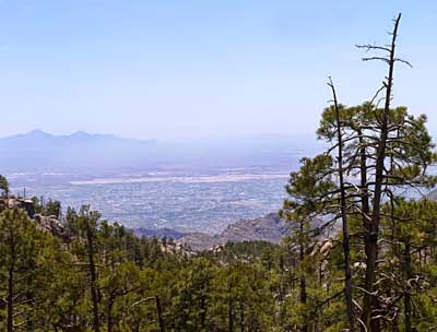
Near the top of Mt. Lemmon looking out at Tucson and the Sonoran Desert


Contained within the Santa Catalina Mountains is the Pusch Ridge Wilderness where we decide a hike in pine trees and aspen was just what we needed.  We hiked the Marshall Gulch Trail and then made a loop out of it by hiking back down the Aspen Trail.  It was almost cold as we were near 8,000 feet.  What a nice change from the desert!  

Thimble Peak
 
The two trails we hiked led through a section of the forest that had a fire in 2003.  It was interesting to see the area after a little more than 10 years recovery.  The new ponderosa pines were nearly 4 feet tall and the faster growing aspens were 15 feet and taller.


David and Maya hiking through young ponderosa pines
with mature ponderosa forest behind

This was the first time in over a year that we have been as high 8,000 feet and we felt it.  After all that exertion we thought we deserved a reward so we allowed ourselves to split a huge chocolate chip cookie at the Cookie Cabin in the little village of Summerhaven near the trailhead.  It was the biggest and most buttery cookie I have ever seen or tasted.  The calorie burn of the hike and the calorie intake of the cookie was probably a net zero. 
 

Taking a well deserved rest
 
Tucson is a place of contrasts – all that nature from desert to pine forests with five mountain ranges surrounding it.  We could have stayed much longer as there were many more places to explore and we didn't do any 'city stuff.'  But we were due in Phoenix for a rendezvous with my cousin and a trip to Young, AZ.  And the desert was getting warm.  March and early April may be the best times to see the desert in bloom and not wilt in the heat. 


David's Stats:
Days Hiked       2
Total Miles Hiked  6.26    
Ave. Miles per Day      3.13
Total Elevation Gain     1,143 
Ave. Elevation Gain per day  572


Thursday, April 24, 2014

Mountain Spirits and Cliff Dwellers


Caves protect the dwellings built by Mogollon Indians between 1276 - 1287


The Gila National Forest is not only rich in scenic beauty and solitude; it is a place of spirits.  Pit homes of prehistoric peoples have been dated to 550 CE.  Many people have walked through this forest since then – from the Mogollon Indians that built the cliff dwellings to the Chiricahua Apache to Spanish and Mexican explorers then Anglo miners, homesteaders and soldiers.
The geology of the area created many riches – the Gila River and its floodplains, plentiful hot springs, a variety of wildlife and a wealth of minerals. No wonder so many people have been attracted to the Gila through the ages.


The preservation of these ruins is amazing!
 
We visited the Gila Cliff Dwellings National Monument after it had rained most of the night on our third day camping in the forest.  The rain was clearing out but we still had drizzle as we arrived at the trail to Cliff Dweller Canyon.  There had been a small rock slide caused by the rain and part of the trail was closed.  Luckily we were still able to go up to see the dwellings.  The trail climbs steeply 180 feet above the canyon floor and the rain made it a slippery walk in places and there were some deep puddles of water to navigate.  Rounding the last curve and catching site of the dwellings made it all worthwhile. 

Inside Cave 5

Thanks to the natural protection of the caves, the dwellings are beautifully preserved.  We roamed the six caves and listened to a ranger interpret the site.  It is believed that 10 – 15 families lived in these caves with about 46 rooms.  But they only lived there a few decades.  Why did they go to so much trouble building their remarkable homes only to abandon them a short time later?  No one knows for sure but cycles of drought have been common in the Southwest and then as now, people have had to cope.  Perhaps they were no longer able to sustain themselves when water became scarce.


The sun started to come out as we headed down the trail.  We spent the rest of the day exploring the visitor center and surrounding areas.  I didn’t know that Geronimo was born near the headwaters of the Gila River.  His family band, Be-don-ko-he of the Chiricahua considered the Gila their homeland.  
One thing I wish I’d made time for was a soak in one of the many hot springs along the Gila River.  Some are commercial but there are several along the river in the forest – the cost of a soak is only a few miles walk. 

Looking down into the canyon from inside Room 5
   
The apple trees were in bloom!


Wednesday, April 23, 2014

Wild Places...


“Like wind and sunsets, wild things were taken for granted until progress began to do away with them.  Now we face the question whether a still higher ‘standard of living’ is worth its cost in things natural, wild and free.” – Aldo Leopold


Pools in the canyon on Little Dry Creek Trail

Two years ago when we first started our travels we had plans to visit the Gila Wilderness.  But 2012 was a big fire season and the Whitewater Baldy Fire was raging in the Gila National Forest and Wilderness.  When it was finally contained late in June of 2012 about 300,000 acres had burned making it the most extensive fire in New Mexico history.  300,000 acres is a lot of forest to burn but fortunately the Gila National Forest is almost 3.3 million acres with one-fourth of it designated as wilderness.
We had never done any hiking in the Gila so this year we wanted to visit and see how it was recovering nearly two years after this devastating fire.  The Gila has long held a fascination for us partly because of its size and remoteness but also because one of our heroes, conservationist and pioneering ecologist Aldo Leopold, was instrumental in the designation of the Gila as the country’s very first wilderness area.  Maybe some of you have heard of Aldo Leopold and know his book, A Sand County Almanac.  It is a must read if you treasure nature.

View of the Gila Wilderness, our country's first wilderness, from the Aldo Leopold Vista

In 1909 after Leopold graduated from the Yale School of Forestry, he accepted a job with the newly formed Forest Service at the Southwestern Regional Office in New Mexico.  I like to picture Aldo Leopold as a wide-eyed young man who had never been out of the east, stepping off the train in Albuquerque into a wild west – a rugged and remote land that would shape him and forever change his life.   Over the next several years influenced by his experiences in the Gila, a new perspective on wildlife management would be born and Leopold would soon discover a passion for ‘wilderness as a resource.’ 

Headed into the wilderness, no roads in site...

Leopold believed that people need the solitude of wild places and he defined wilderness as enough undeveloped land that a person could ride horseback for two weeks and see no roads or houses or other signs of civilization.  Leopold’s vision helped inspire the 1964 Wilderness Act that now preserves the wildness of over 109 million acres of federal public lands.   David and I are doing our best to spend some time walking and camping in as many of those wild places as we possibly can. 

Little Bear Canyon

“We abuse land because we regard it as a commodity belonging to us.  When we see land as a community to which we belong, we may begin to use it with love and respect.” – Aldo Leopold  


From Silver City, the Trail of the Mountain Spirits National Scenic Byway winds its way from the high Chihuahuan desert through narrow canyons to the snow-touched wilderness and headwaters of the Gila River.  After driving this beautiful byway we camped just a few miles from the Gila Cliff Dwellings on the edge of the national forest.  The next few days we took hikes into the wilderness along the middle and west forks of the Gila River and visited the cliff dwellings. 
Maya in the Middle Fork of the Gila River
 
Some of the trails into the wilderness were in very bad shape.  First there was the fire two years ago and then this past September there was a big flood.  Many of the burned trees were uprooted and washed into the Gila River.  We talked to one group of hikers that said they just gave up at one point and hiked down the middle of the river, it was easier than trying to follow the trail blocked with downed trees.  The Gila is pretty deep and swift in places and we didn’t think we were prepared for immersion in cold water most of the day so we avoided those trails.  (Maya probably wouldn’t have minded it, but we aren’t as tough as she is.)

Burned area along the West Fork of the Gila River

Our hikes, while definitely not as adventurous, were still a lot of fun.  We took the higher and drier trails through smaller canyons but still hiked down to the rivers.  David and Maya came within inches of a beautiful (and large) Blacktail Rattlesnake.  Lucky for us these snakes are generally docile and this one was still sluggish and cold - he didn't even rattle at us.  But that was exciting enough for us. 


Sluggish Blacktail Rattlesnake
 

And here's the black tail in the lower right corner


One of the burned areas

We did pass through some of the forest that was burned, but it was more of a mosaic of burned and unburned forest.  The wild flowers were putting on quite the show, probably benefiting from the extra light reaching the forest floor after the burn.  On our hike closer to the cliff dwellings we saw several sets of hikers and backpackers but on our hike through Little Dry Creek Canyon it was just us, the pool-filled canyon and the solitude of the wilderness. 


Columbine


Soaking tired feet in a cool mountain stream is wonderful!
 
 
David’s Stats:
Days Hiked    3
Total Miles Hiked   17.17
Ave. Miles per Day      5.72
Total Elevation Gain       2,574
Ave. Elevation Gain per day   858

Monday, April 21, 2014

Some Enchanted Evenings...


"On the road" from New Mexico

It is Easter Sunday evening and David and I just enjoyed a sublime New Mexico sunset.  The Land of Enchantment sure knows how to do sunsets and we have been enjoying our share this past week.  At last we are ‘on the road’ and it feels fine.

On April 14 we left Odessa, saying goodbye to my parents.  They are our last stop before we begin our journeys.  Mom and dad had a big year, both of them turning 80 in 2013.  This summer they will have their 60th wedding anniversary!   It is always hard to say goodbye to them but it feels good that they are so supportive of our adventures.  Still, I am really going to miss them… 
 
Lea Lake, the largest of the 'bottomless' lakes at 90 ft. deep
 
As we crossed the New Mexico border on that straight and seemingly endless road to Roswell it finally seemed like the journey had begun.   After having dinner in Roswell with our long-time friend Steve, we spent our first night at Bottomless Lakes State Park.  A popular swimming hole for the locals, the lakes are cool and deep, but not really ‘bottomless.’ This time of year the park is one of those places that easily could be overlooked but on our first night out it was enchanting – a stroll to watch birds along the wetland, a beautiful sunset and the full moon rising.  Much later that night some people watched the full eclipse of the moon. 

City of Rocks State Park

The next day we headed to Las Cruces in time to have lunch with my mom’s favorite cousin before spending our second night at City of Rocks State Park north of Deming, NM.  City of Rocks was a place we had never been and it was definitely worth the trip.  By day, the park is impressive enough with its jumble of huge tuff formations.  But at sunset it really rocks!  The colors intensify and the shadows animate the rocks creating a ‘rock city,’ thus the name.


About 34 million years ago this part of New Mexico experienced a very large volcanic eruption of ash 1000 times larger than Mt. St. Helens. Tons of ash were deposited in this formation known as the Kneeling Nun Tuff.  Then the weathering process started.  Millions of years of wind and water and freezing and thawing sculpted the rows of monolithic blocks.  The rock formations at the park are so unique that they are only known to exist in six other places in the world.  (I’ll have to find out where those other six places are…) 


After wandering the ‘avenues’ of the Rock City and enjoying the desert in bloom we traveled a few miles down the road to Silver City.  We had a great time sightseeing and visiting the museum on the campus of Western New Mexico University where we saw some beautiful Mimbres pottery.  The next day we drove the Trail of the Mountain Spirits National Scenic Byway up to the wild and remote Gila Wilderness to spend several nights ‘away from it all.’


The desert in bloom, claretcup hedgehog cactus


We are back in Silver City tonight and have electricity, phone and Internet again.  What a great first week ‘on the road.’  I’ll be telling more about our wilderness adventures in just a day or so…