Sunday, June 21, 2015

Sleeping Bear, Hiding Lake


Large dune in fog on the shore of Lake Michigan 
at Sleeping Bear Dune National Lakeshore


Anishinaabek Indian legend has it that long ago, in the land that is now Wisconsin, a mother bear and her two cubs plunged into Lake Michigan to avoid a raging forest fire.  As they swam and swam, the cubs became tired and lagged far behind.  Mother bear finally reached the opposite shore in Michigan and climbed to the top of a bluff to watch and wait for her cubs.  But the cubs didn’t make it.  Today “Sleeping Bear,” a solitary dune over-looking Lake Michigan, marks the spot where mother bear waited.  Her lost cubs are the two Manitou islands just off shore.

Crazy people crawling up the really steep dune in the fog
 
This American Indian story may have been the first explanation of how the large sand dunes and other features of the land near Sleeping Bear were created.  In more recent times scientists have followed geologic clues to explain the complex landscape.  First, shallow warm seas covered the area followed by the powerful earth-moving forces of glaciers, wind and water.  Glaciers left behind a sandy coast on the windward side of Lake Michigan and the prevailing westerly winds and lake waters did the rest.
 
Basswood tree struggling to keep rooted in the ever-shifting sands
 
Much of the land around the Great Lakes has this ‘dune and swale’ landscape formation of beach dunes with narrow swales separating the dunes.  The swales are wetlands containing pools with grasses, sedges and ferns.  This is ideal habitat for migrating and nesting birds. 

Sleeping Bear Dunes National Lakeshore, managed by the National Park Service, has some of the largest dunes in the Great Lakes.  The park’s namesake, Sleeping Bear Dune, is actually a glacially formed bluff topped by sand that towers over 400 feet above Lake Michigan.
 
Young and old alike enjoy the 'Dune Climb' in their own way
 
We learned all this cool stuff on the Pierce Stocking Scenic Drive that we took our first afternoon in the park.  It was still cloudy and foggy with visibility only about half a mile or less so Sleeping Bear Dune and Lake Michigan were nowhere to be seen.  But we could learn about them, imagine what they would look like and see some of the other sites on the scenic drive.  One spot in the Sleeping Bear Complex of dunes, the Dune Climb, was easily accessible so we could see all the people climbing that dune.
 
Lake Michigan with Sleeping Bear Dune in the distance
Sun makes all the difference!
 
The next morning David came in from his early walk with Maya and woke me with the news that the sun was out.  We quickly had breakfast, fixed a lunch to put in our packs and headed out for a hike to Lake Michigan.  It was a glorious day – crisp, clear and cool.  We hiked through shady beech-maple forests to the open, sunny dunes and yes, a view of deep blue Lake Michigan with Sleeping Bear Dune in the distance.  I guess there is nothing like a few days of damp foggy weather to make a clear sunny day seem even more beautiful.


Lake Michigan in fog


Same place, next day -- what a difference!


We have one last stop to make on the shores of Lake Michigan at Wilderness State Park on the very tip of the ‘mitten.’  A few days in this park near Mackinaw City and then it is on to the U.P. or Upper Peninsula to spend a couple of weeks.


Dune erosion at work
Pyramid Point


David’s Stats:

Days Hiked:  1  
Total Miles Hiked:   5.64  
Total Elevation Gain:  967  


Saturday, June 20, 2015

West: To the other side of the 'Mitten'


Lake Michigan?


Leaving Lake Huron, we traveled west across the state to spend several days on the Lake Michigan side of the ‘mitten’ before heading to the upper peninsula.  We stopped at Orchard Beach State Park just a few miles north of Manistee to spend the night.  It was a gray and foggy day and there was no view to be had of Lake Michigan.  People said there was a lake across from our campsite but we didn’t believe it.
 
Downtown Manistee
 
After getting ourselves settled in the park and having a look for the lake that wasn’t there, we decided to drive back a few miles to the cute little town of Manistee and have a look around.  Maybe we would be able to see the lake from there.  As we approached the downtown area there was still no lake view but we noticed that a car show was being held on River Street.  Well at least we could look at downtown and cars.


Manistee Car Show on River Street

Maya checks out the car show and finds a friend


It was actually a good show with quite the variety of vintage and antique cars and trucks.  Lots of people were enjoying themselves listening to classic 50’s and 60’s music and checking out the cool cars.  We got into the spirit of things ourselves and were glad we made the trip into town.


Back at the campsite the fog was still there, maybe worse.  We had a good sleep and bright and early the next morning, there was still no lake to be seen.  So, we hiked Orchard Beach’s nature trail and were reminded of our fifth grade geography/geology lessons on glaciers and how the Great Lakes were formed.  Lake Michigan, like the rest of the Great Lakes, was not always a lake.  Before the Ice Age, the Great Lakes were stream valleys.  It was only after the Ice Age, once the glaciers had sculpted the region into much of its present shape, that the lake basins were filled with water from the melting glaciers.
 

View of a meadow from the Orchard Beach Nature Trail


Meadow wildflowers


Following our hike, we struck camp and drove about 60 miles north to Sleeping Bear Dunes National Lakeshore to spend a couple more nights on the shores of Lake Michigan.  Maybe there we would get a glimpse of the illusive lake…


David’s Stats:

Days Hiked:  1        
Total Miles Hiked:   0.94  
Total Elevation Gain:   83 


Tuesday, June 16, 2015

Tip of the 'Thumb' and up the Mitten


Sand dunes, grasses and native flowers along the shores of Lake Huron


The main part of Michigan is shaped like a mitten and Detroit is located more or less at the base of the thumb.  We decided that the next destination in our ‘survey’ of Michigan would be Port Crescent State Park on Lake Huron at the very tip of the thumb.  Then we would take a little jaunt up the inside of the mitten to Tawas Point State Park before heading west to the Lake Michigan side of the state.
We arrived at Port Crescent State Park in the early afternoon after a rainy but nice drive.  Much of the thumb was originally forested but now it is nearly all farmland and we passed through field after field of newly planted corn, grains and vegetables.  Along the coast of Lake Huron and around the state park the land is still a mix of hardwood and pine forests with sand dunes covered in grasses near the lake.


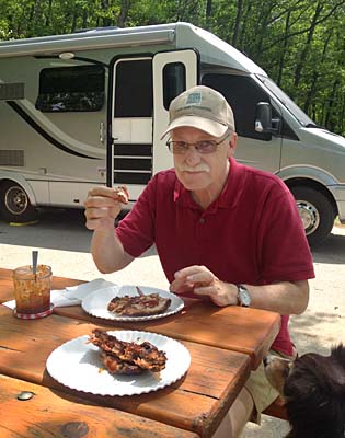
Picnic of smoked ribs
Maya hopes for a bone
 
By the time we found a campsite and set up, the rain had cleared and we were starving.  Fortunately, Jim had sent a care-package of his smoked ribs along with us and we had a delicious picnic lunch with very little effort on our part.  We spent the remainder of the afternoon and evening enjoying the improving weather and strolling along the lake.
The next day dawned bright and clear and we seized the moment by heading out on a nature trail.  From dunes with beach grasses and jack pines to wetlands to forests we learned about the different ecosystems in the park and experienced the rolling dunes and swales of the terrain.  By afternoon the rain had moved back in so we were really glad we had gotten our hike in early.


Maya cools off in Lake Huron after our nature hike


Next we headed to Tawas Point which was only about 50 miles across Lake Huron but since we couldn’t fly across, we had to drive about 120 miles down the thumb and then back up the mitten.  It took us closer to 3 hours and of course it was raining so that slowed us down too.
 
Tawas Point Lighthouse
 
We were going to stay in the state park but there was a big crowd because of the upcoming Tawas Point Celebration Days and with all the rain we opted for a commercial campground nearby.  As it turned out we were very glad we stayed two days at Tawas RV Park.  Usually I am not all that excited about commercial campgrounds, but this was a very quiet, secluded and friendly place. 

Thanks to Maya we met almost everyone and their dog (pretty much everyone had a dog).  Many of the people at the campground were ‘seasonal campers.’  Most lived in Michigan and spent their summers at the park.  A few were from other states, the farthest away being Florida. We were invited to the group campfire and received many suggestions on where we should visit in Michigan. 


Civil War re-enactor at Tawas Point Celebration Days
 

The next day we visited the Tawas Point Lighthouse for the ‘Celebration Days.’  There were re-enactors in costume, demonstrations and food.  We visited the lighthouse, walked along the point and ate of course.  It was a foggy, cloudy day thus not as picturesque as it could have been, but we didn’t get rained on. 
After a nice night in our RV park, we said goodbye to our newly-met friends with wishes for safe travels and invitations to return and spend the summer.  We were ready to continue on our journey this season, but it was a good feeling to be 'at home' for a few days among such nice people.


Beach Pea, a native dune plant that helps control dune erosion


David’s Stats:

Days Hiked:  3
Rain Days:    2    
Total Miles Hiked:   10.56  
Ave. Miles per Day:      3.52
Total Elevation Gain:     593
Ave. Elevation Gain per day:   198 


Saturday, June 13, 2015

Visiting Jim and family...


Swans and babies in the Huron River at Proud Lake State Recreation Area


David’s brother lives in a western suburb of Detroit within about 15 minutes of Proud Lake State Recreation Area.  That worked out great for us – we got to stay in a beautiful state park away from traffic and noise and yet still be close to Jim and his wife Harumi.  We’ve all been having a great time talking, eating good food and site-seeing so I’m a bit behind on the blogging.  What follows is a summary of some of the highlights of our visit.


Wetland area at Proud Lake
 

Saturday was our first full day in the Detroit area and Jim brought Harumi and her soon to be 14-year-old daughter, Shiori, out to Proud Lake for a hike.  The ‘girls’ wanted to try some hiking and as David, Maya and I are always ready for a walk in the woods – it was the perfect opportunity to introduce them to one of our favorite things. Jim’s knees are not quite up to hiking these days, so he stayed behind at the RV with a good book and the rest of us hit the trail.

 
We watched a turtle lay eggs near our campsite


Covering the eggs
We told the park staff about it and they put up a little fence to protect the nest


There are over 20 miles of trails at Proud Lake with an amazing diversity of terrain including two lakes, a river, a marsh, forests, fields and wetlands.  On our hike we circled the marsh, wound through woodlands and paralleled the Huron River to a beautiful swimming spot.  Only Maya went for a swim as it was a cool morning and the water temperature was still too chilly for us.  It was our first time to meet Shiori and only our second time with Harumi so we all enjoyed getting to know each other better on our most excellent hike.

That afternoon Jim took all of us to his favorite neighborhood Mexican food restaurant where we ate a late lunch.  Harumi’s son, Takuya, came along and we had a nice meal with Jim’s new family.

 
Takuya, Jim, Harumi and Shiori

 
Sunday was a good day for hanging out at Jim and Harumi’s apartment.  Jim spent 5 hours smoking ribs while David did the laundry.  The three of us girls went out for a little shopping while the guys did most of the work – as it should be. 

We also got to see Tama, Jim’s cat that we gave him several years ago.  My friend Jose found Tama as a small kitten hanging out in the trash dumpster at a Mexican restaurant in San Antonio.  Tama stayed with us at our house for a few days and we thought about keeping him but we gave him to Jim that Christmas.  Then the little guy gave us ringworm -- a memorable Christmas to say the least. Poor kitty, it wasn't his fault.  We were glad to see Tama again after all this time and see that he has made the adjustments from a street kitten in San Antonio to a bachelor pad in Ft. Worth to a happy family in Michigan.  He’s one lucky kitty.
 
 
Tama relaxing with Jim

 
Monday was a school and work day for everybody but us ‘retirees’ and we took the opportunity to do some sight-seeing around Detroit.  You hear and see so much on TV of the effects of the economic downturn on Detroit and we did see some of that as Jim showed us around.  But all in all we thought downtown Detroit looked pretty good and like things were getting better.  And being spring, everything was so green and beautiful, even the empty lots where houses had once been.

 
Detroit skyline from Belle Isle looking across the Detroit River


Church near downtown


Tuesday David and I spent the morning doing some more hiking around Proud Lake.  The trails were excellent and the insects and poison ivy were minimal so we wanted to enjoy that.  Those conditions have been hard to come by this spring!  After a fine morning enjoying the trails we met Jim and Harumi for a late lunch. The lunch at Indo-Fusion was delicious and spicy, a Portuguese Indian mix of mostly curries.  We were glad we ordered it ‘medium’ and not ‘hot.’


A chicken and vegetable curry -- as good as it looks...
 

The rest of the afternoon flew by and then David and I said our goodbyes as we planned to leave out the next morning for the 'thumb' of Michigan.  It was such a nice visit and we didn’t want to wear out our welcome.  After all, we do hope to be invited back again.
 

David’s Stats:
Days Hiked:  2  
Total Miles Hiked:  7.79   
Ave. Miles per Day:    3.90 
Total Elevation Gain:    174
Ave. Elevation Gain per day:   87 


Tama


Monday, June 8, 2015

Ohio to Michigan


Lake Erie from East Harbor State Park


As it seems to happen frequently this spring, we are often packing up in the rain and leaving Louisville was no different.  All the way to Cincinnati we were in and out of rain showers.  As we traveled north past Dayton the rain turned to light sprinkles and by the time we reached Lake Loramie State Park, a good stopping place for the night, we were left with only clouds.

Lake Loramie is one of the original canal feeder lakes that used to supply water for the Miami-Erie Canal system.  The park is located southwest of Lima in western Ohio, not really on the way to anywhere.  But it wasn’t much out of our way as we headed for the shores of Lake Erie.  We had thought to maybe stay two nights and do a bit of hiking around the lake enjoying rural Ohio but there had been too much rain and the trails were more like lakes themselves so we just stayed one night and drove on to Lake Erie the next morning.
 
Marblehead Lighthouse
 

On Lake Erie, we stayed at East Harbor State Park for a few days and put another Great Lake 'notch in our belt.'  Until two years ago, Lake Michigan around Chicago was the only Great Lake we had seen.  When we were in New York two summers ago, we spent almost a week enjoying the beauty of Lake Ontario.  Two down, three to go… And we plan to complete seeing all the Great Lakes this summer.
 
A good year for goslings
 

East Harbor State Park is situated on a peninsula of land that stretches out into Lake Erie in almost a ‘T’ shape.  Lake Erie is the shallowest and warmest of the Great Lakes but it still felt pretty cold to us.  Besides some nice beaches along the harbor and Lake Erie, much of the park is wetlands.  This area was part of the Great Black Swamp which once covered a portion of northern Ohio 120 miles long and 30 – 40 miles wide.  After lumbering and then draining for agriculture in the late 1800's only ten percent of Ohio’s original wetlands remain.  
 
A remnant of the Great Black Swamp, East Harbor State Park
 

We did some hiking along Lake Erie, East Harbor and the wetlands.  The birding was amazing – ducks, geese, swans, gulls, terns, great blue herons, black-crowned night herons, egrets and a golden eagle were among the birds we saw.  Some of the wetland trails were very wet and we were glad of our waterproof hiking boots.  All in all the hiking was easy and enjoyable but the last trail we did was thick with mosquitoes making it not quite as much fun as previous walks.  Oh well, it’s a wetland and mosquitoes are to be expected.

After our hikes and some car touring, including Port Clinton, Catawba State Park, Marblehead Lighthouse State Park and Lakeside Chautauqua we drove on to Detroit to spend several days with David’s brother and his wife Harumi.  We’ve been getting in some good visits and were treated to some amazing home-smoked BBQ ribs yesterday.  Jim is a very good cook!  We may be staying longer than he knows…


David’s Stats:

Days Hiked:   3  
Total Miles Hiked:  8.51   
Ave. Miles per Day:   2.84  
Total Elevation Gain:     278
Ave. Elevation Gain per day:  93 


Monday, June 1, 2015

As We Like It...


Rock Bridge Arch, Red River Gorge Geological Area
A type of arch known as a waterfall arch as it was formed by a waterfall


Memorial Day is often called the ‘unofficial’ beginning of summer and the increasing temperatures we have been experiencing this past week were reminding us of this fact.  It was time to start moving north, plus we promised David’s brother we would be in Michigan the first week of June.  However there was time for a couple more stops in Kentucky and then maybe a few days in Ohio on our way to Michigan.
 
One of many small waterfalls on the Rock Bridge Arch Trail
 

From Cumberland Falls State Park we traveled north and a little east to the northern part of the Daniel Boone National Forest.  This part of Kentucky is home not only to magnificent hardwood forests with almost as much biodiversity as the Great Smoky Mountains but also some unexpected and unique geological formations.
 
Princess Arch
 
A princess poses under Princess Arch
 

We camped at Natural Bridge State Park next to the Red River Gorge Geological Area administered by the National Forest Service. Between the two areas there are over 100 bridge and arch formations surrounded by heavily forested slopes, ridges and cliffs.  We did not know Kentucky had natural stone arches like Utah and its own Red River, the state’s first and only National Wild and Scenic River.  
 
Top of Princess Arch
It was so cool to be able to walk on top and underneath the arch
 
We were so glad we spent a few days in this area.  The scenery was gorgeous.  The wind-sculpted bridges, arches and towers were so different from the ones in Utah.  Rather than standing out in the landscape, they were hidden in the lush vegetation, behind ridges and at the end of narrow, winding trails.  Sometimes you had to look a little to see them.  But it was well worth the looking.
 
Angel Windows
 
Rock ledge shelter on the Angel Windows Trail
 

Bordering the Red River Gorge on the east is the Clifty Wilderness where we had our best hike of this season so far.  We hiked to the Rock Bridge Arch, still in the gorge area, but then followed the Swift Camp Creek Trail into the Clifty Wilderness.  This trail reminded us so much of the Appalachian Trail around the Smoky Mountains.  We hiked through green tunnels of rhododendron with tulip trees, hemlock, hickory and oak as the canopy.  The trail mostly followed the Swift Camp Creek into the silent, dark wilderness where, for all we could tell, we were alone in the world.  Poison ivy was minimal and no ticks were found.  It was, except for being a little warm, as we like it.  And about time!
 
Swift Camp Creek Trail in the Clifty Wilderness
 
Looking down on Swift Camp Creek
 

Next we drove I-64 to Louisville.  As we neared Lexington, we began to see the Thoroughbred Farms with horses grazing in the fields of bluegrass.  We were only in Louisville for a day and a half but we had time for a little touring and we visited Churchill Downs.  There were only a few live races that afternoon so we didn’t stay long but the little girl in me who loves horses had to see Churchill Downs.
Kentucky has so much to see and do and we didn’t make it to many places – Mammoth Cave, Fort Knox, Abraham Lincoln’s Birthplace, and all those museums, the Corvette Museum and the International Bluegrass Music Museum – just to mention a few.  Another time, another trip, if we are lucky…

Posing by Rock Bridge Arch
 

David’s Stats:

Days Hiked:  2  
Total Miles Hiked:   8.76   
Ave. Miles per Day:    4.38 
Total Elevation Gain:  1,190  
Ave. Elevation Gain per day:   595