Sunday, September 30, 2012

Rowe Lake Hike, Waterton National Park, Canada


Goodbye Canada!


Our last day in Canada we drove the Akamina Parkway to hike Lower and Upper Rowe Lakes Trail. The trail was 8 miles total with an elevation gain of 1886 feet - not as arduous as some of our more recent hikes, but still a great walk.  The ground cover and understory - thimbleberry, huckleberry and maple were all turning yellow and red.  And the larch!  We had never seen larch turning gold before, so it was a real treat.  What a fantastic day and a nice way to say goodbye to Canada. 

Huckleberry
Upper Rowe Lake

Turning Larch


Larches at Upper Rowe Lake


Waterton Lakes National Park, Canada


Big Horn Sheep on Red Rock Parkway, Waterton Lakes N. P.


Our last stop on our tour of Canadian National Parks was Waterton Lakes National Park. We stayed in Waterton Townsite Campground on the shore of gorgeous Upper Waterton Lake. Looking out our RV window we could just see the famous Prince of Wales Hotel.  We fell to sleep with the gentle sound of waves from the lakes.

Red Rock Canyon Loop Trail

The next morning we drove the Red Rock Parkway and four female Bighorn Sheep were on the road right as we turned onto the Parkway. We had a beautiful hike on the Red Rock Canyon Loop and then the Blakiston Falls Trail. The trails wound through a colorful valley with a little river that cut through brick-red mudstone. The red rock was an argillite, harder than shale but softer than slate, formed from iron-rich sediments that were deposited on ancient tidal mud flats. The leaves were just beginning to turn, so that added to the beautiful color.  It is hard to believe that fall is here...


Fall Color on Blakiston Falls Trail
 
Red rock stream


Lake Louise Hike


The beginning of the 'adventure' on the shores of Lake Louise

For our last day in Lake Louise we planned another one of our 'mega' hikes and combined 3 trails to make a loop around Lake Louise. We started at Chateau Lake Louise, taking the Plain of the Six Glaciers Trail to a high mountain teahouse and then continued on above the timberline to the best views of glaciers and vaulting peaks yet. From there we took the Highline Trail over to Lake Agnes which also has a teahouse on its shore. (Plenty of opportunities for tea with stunning views!) The Lake Agnes Trail returned us back to the shores of Lake Louise and our starting point in front of the Chateau. 

Climbing higher on the Plain of Six Glaciers Trail
Past the teahouse on the Plain of Six Glaciers Trail with Lake Louise in the background
Glaciers above and below!
Clouds, wind and glaciers


Larch just starting to turn
 

Lake Louise, Banff National Park, Canada


Chateau Lake Louise from the Lake Agnes Trail

Lake Louise in Banff National Park is perhaps one of the better known destinations in the Canadian Rockies. Many visitors come to Lake Louise on the train, 'The Pacific Orient Express' from Vancouver. The famous Chateau Lake Louise, built by the Canadian Railroad graces the shore of the emerald-hued lake. The lake changes color with the seasons, in the winter and spring it is a deep emerald green but in summer and fall it changes to a milky blue-green with all the glacial 'flour' or finely ground rock deposits from the melting glaciers.

Along shore of Lake Louise


We loved Lake Louise so much that for the 8 days we were in Banff National Park we camped 6 of those days in Lake Louise. We had all kinds of weather - from beautiful sunny days to rain to snow flurries and even 27 degrees Fahrenheit early one morning.  But nothing stopped us from enjoying our time in Banff National Park. 

Johnston Canyon, Banff National Park

A soaking wet Maya in Johnston Canyon
 
A drier day on the Bow Glacier Falls Trail
 
Bow Lake

                                                      Bow Lake - opposite shore 


Friday, September 28, 2012

Jasper National Park, Canada

Jasper National Park, Canada

After spending the previous day driving the magnificent Icefield Parkway, we arrived at Whistlers Campground in Jasper National Park just a few miles outside the town of Jasper, Alberta.  A gentle rain started to fall just as we were finishing our dinner and we heard a male elk 'whistling' in the distance making us think the campground was aptly named.

The next day was rainy so we explored the town, bought groceries and did a little laundry.  Later in the afternoon as it cleared a little we hiked along Maligne Canyon, a narrow slot canyon carved by the Maligne River into the softer "karst" limestone.  We hoped to get a look at the rare black swift that makes its summer home in the canyon.  Many bird watchers come to Maligne Canyon in hopes of viewing this bird.  Luck was not on our side as far as the birding went, but the canyon was beautiful.
David and Maya on the Wilcox Trail
 
Part of the Icefield Parkway is in Jasper National Park and one of the hikes we wanted to take was down the Parkway, not too far from the Athabasca Glacier. Lucky for us the rain moved out during the night and we had a beautiful sunny day ahead of us.  We hiked the Wilcox Pass Trail, a short trail at a little over 3 miles that climbed up the valley and had great views of the glaciers and icefields. The perspective from high up on this trail was even grander than the views from the Parkway.
View of Athabasca Glacier from Wilcox Trail
David and Maya with Athabasca Glacier in background
 
 
We enjoyed another fantastic hike and to top it off we saw a grizzly from the road as we were driving back.  The bear was too far away to get a good photo, but we watched as it dug for insects and roots for several minutes before wandering back into the forest.  A nice end to a beautiful day!


Thursday, September 27, 2012

Driving the Icefield Parkway in the Canadian Rockies


Canadian Rockies along the Icefield Parkway

The next adventure on our agenda was to drive the Icefield Parkway (Alberta 93) from Banff National Park to Jasper National Park. I can understand why National Geographic Magazine called this one of the ‘World’s Ten Greatest Drives.’ This is an amazing drive through the backbone of the Canadian Rockies journeying through several icefields and glaciers that straddle the Continental Divide. Vast wilderness, sweeping valleys, pristine mountain lakes, waterfalls, wildlife and glaciers – it would be hard to find a more scenic and diverse drive.


Another gorgeous view along the Icefield Parkway
 
Columbia Icefield
 
After stopping many times at the scenic pullouts we reached the Icefield Center located near the Columbia Icefield. The Icefield Center was built on the glacial moraine of the Athabasca Glacier – the building stood where the ‘toe’ of this glacier ended 125 years ago.  The Athabasca Glacier is now located about ½ mile away and across the highway from the center.

Photos of the Columbia Icefield and its glaciers from 125 years ago are on exhibit as well as much information about glaciers and their formation, the geology they create and predictions of where the icefield and its glaciers may be 125 years from now.  Standing on the deck at the center and looking across the valley at the Athabasca Glacier really brought home how much the earth has warmed over the last century.

Athabasca Glacier across from Icefield Center
 

Wednesday, September 26, 2012

The Iceline Trail, Yoho National Park, Canada


We did have one gloriously beautiful day in Yoho. So that called for one spectacular signature hike. Be careful what you wish for... 
View of Emerald Glacier about one quarter of the way up the Iceline Trail

The Iceline Trail had been recommended to us as a fantastic hike and we decided that this was the hike we must do. About 18 km or 11 miles and 2,259 feet elevation gain with amazing views, alpine meadows and lakes, glaciers and rock staircases - what could be better? Well, we could have been at the end of it.  But it was worth it, we think...

Celeste Lake on Iceline Trail

Are we there yet?
Not much farther, we hope...

Emerald Glacier near top of Iceline Trail

Glacial melt lake, Emerald Glacier

View of Takakaw Falls from top of Iceline Trail

Yoho National Park, Canada


Hoping to escape the rainy weather or at least get a little warmer, we travelled Trans-Canada Highway 1 to the next park, Yoho National Park.  The word Yoho is a Cree Indian expression meaning "awe."  Yoho was the first of the Canadian Rocky Mountain Parks we visited and the Cree definitely got it right.  The terrain was not vastly different from the Columbia Mountains in Revelstoke and Glacier - but wider valleys with more open views of towering rock walls, those glorious Rockies.
Kicking Horse River near Kicking Horse Campground
 
We camped at Kicking Horse Campground near the Kicking Horse River and the town of Field.  Being used to American National Parks, it was a little strange to us for there to be towns, the railway, a major highway and some development inside the boundaries of the national parks.  However since the railroad came first and was responsible for the establishment of many of the parks, it made sense that there were a few towns along the way.  The vastness of the parks and lack of development except along the railway corridor insure that the visitor can still be very remote from civilization.
Daisies on shore of Emerald Lake - very rainy day
 
Alas, we did not escape the rain or the cold but we were able to get in several hikes and some sightseeing. We drove and explored the Yoho Valley Road and took a short hike to Takakaw Falls. The next day we hiked around Emerald Lake in the rain. Then we warmed up with a nice lunch of soup and fish at the Truffle Pig Bistro in Field (an advantage to having towns in National Parks).

Takakaw Falls in Yoho Valley

Saturday, September 22, 2012

Rainy Day in Glacier National Park, Canada


Cold, rainy day in Glacier on Rock Garden Trail
 
The colder weather started almost as soon as we arrived at Glacier. Our first two days had highs in the low 50's and were mostly dry. But then the rains came and made long hikes a bit more daunting.  We had rain gear but still didn't want to be hiking in cold pouring rain all day for Maya's sake as much as our own. So after an overnight low of 37 and rain still coming down the next morning, we decided a 'camp day' was in order. 
We used the morning to cook warm, comfort food -- steel cut oats for breakfast, tomato soup and grilled cheese sandwiches for lunch and 'Chili Blanco' for dinner.  We stayed cold for most of the morning since we had not used the furnace before and had to figure out how to make it work. After a little grumbling and consulting our owner's manual, David finally got the heat going.
Our Canadian National Park Campground, like the American counterparts, had no power just water and very cold water at that.  So with no electricity for our microwave or convection oven, just two small gas burners on our stove and the gas furnace in the RV for a little heat we prepared our meals. 
Cooking several hot meals on two little gas burners in a tiny kitchen with next to zero counter space was quite challenging.  We were tripping all over each other and there were dirty dishes and food all over our 200 square feet. Until the cold weather, we cooked outdoors quite a bit and had not prepared so much food at one time. Add poor Maya as a speed bump and it was getting ugly.  (Bless her, she was trying to keep out of the way, but it just wasn't working for any of us...)
 
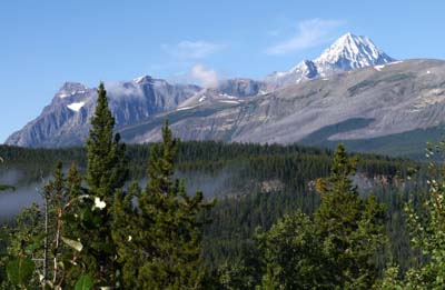
Rock Garden Trail in Glacier
 
Thank goodness about 2 pm the rain let up a little and we decided we could risk a short hike. We drove to the Rock Garden Trail just a few miles away and hiked through a very old rock slide that over time became covered in lichens and moss.  It truly was a ‘rock garden’ as many of the huge boulders were completely covered in moss and had almost bonsai looking trees growing on them and several types of lichens covered other rocks.  It was a bit precarious as the trail over the rocks was wet and slippery, but it was very beautiful to see this special place.  And we had hot white bean and chicken chili waiting for us back at camp.  The day ended much warmer and happier than it started.
 
'Map' Lichen on a rock


Columbia Mountain Ranger Talk


High mountain winter habitat for woodland mountain caribou
 
During our time in Glacier and Revelstoke we were able to take in a Ranger 'Campfire' program one evening.  So here is a little Ranger humor, "Do you know how to tell the difference between black bear and grizzly poop?  Black bear scat has seeds and berries in it and grizzly's smells like pepper and has little bells in it."  I love Ranger humor...  Seriously from the talk we learned more about the inland temperate rainforest and other ecosystems in the Columbia Mountains and about one of its special animals, the woodland mountain caribou.
The temperate rainforest is not the only ecosystem in the Columbia Mountains. The subalpine forest, the alpine tundra and the avalanche chutes are the three other life zones in this area, each with its own unique plants and animals. The ranger said that it might be more correct to call the Columbia Mountains a ‘snow forest.’  Annually about 50 feet of snow and 24 inches of rain fall in Revelstoke and Glacier National Parks. Most of the moisture in this rainforest comes from snow and snow melt.
Inland temperate rainforest - woodland mountain caribou habitat
 
We also learned about the woodland mountain caribou that has dwindled to only 7 animals here in these 2 parks.  This species of caribou has especially adapted to go up into the mountains in the winter rather than down into the valleys like the other species of caribou. They can eat the boxwood and other shrubs that grow in old growth forests and then as the snow covers these plants they can switch to eating lichens. They are able to ‘splay’ their large hooves and dew claws like snow shoes which allows them to walk on top of the snow to reach the lichens growing on branches. What cool survival adaptations!  But as the old growth forests diminish so does their habitat.  Much research is going on now to try to help the caribou re-establish in Glacier and Revelstoke.

Lichen, a preferred food of the caribou


Glacier National Park, Canada


Columbia Mountains near Loop Brook Campground, Glacier National Park

Loop Brook Campground in Glacier National Park was where we camped during our stay in the Columbia Mountains. The campground was located on the site where the Canadian Pacific Railroad started its 'loop' into the Columbia Mountains and eventually into the Rocky Mountains through Roger’s Pass.

We walked the interpretive trail located in the campground and learned much about how the Canadian Pacific Railroad was constructed through this challenging area. To keep the grade at the required 2.2 % for the railway, a new design was needed and tall wooden trestles were constructed that took the train through almost figure 8 loops as it climbed the pass.  Later the wood trestles were replaced by stone and steel trestles.  Many of the stone and steel trestles still stand around the campground today although the trains now go through a series of tunnels.
View of stone trestles near Loop Brook Campground
 
In order to promote the railroad and create more business for themselves, the Canadian Pacific Railroad highly promoted travel in this beautiful area of Canada.  In fact, the CPR was mostly responisible for the Columbia Mountain and Rocky Mountain parks being established.  It was interesting to hike through the forest and see the old train bed and stone trestles and imagine what an adventure it would have been to take a train through this dangerous pass during the Victorian era.


Thursday, September 20, 2012

Images of Revelstoke National Park, Canada


Wildflowers along Summit Trail in Revelstoke N. P.
 
One of the great things about Revelstoke National Park is that the one road leading into the park, called the “Meadows in the Sky Parkway,” does quite a bit of climbing. So the road did much of the work and David and I were able to take quite a long walk into the alpine because we didn't have to spend so much time and effort climbing to elevation.  

We took the Summit Trail through a subalpine forest which then connected with the Miller Lake Trail.  We still had about 595 feet elevation gain but it would have been so much more if we had to start at the bottom of the road. The two trails wound through meadows, boulder fields, above the tree line and eventually to a gorgeous alpine lake.
 
Miller Lake
 
 
The wildflowers were magnificent -- still gorgeous the first week in September.  Each turn in the trail brought a new meadow with even more gorgeous ones. I made a ton of photos but nothing does it justice, it must be experienced. And cameras can't capture the sweet smell.