Friday, May 29, 2015

Holiday at the KOA


Camping at the KOA


Holidays on the road are always a dilemma for David and me.  Do we brave the popular national or state park campgrounds with hundreds of our soon-to-be closest friends or do we stay in a commercial campground in a city with hundreds of our soon-to-be closest friends?  Neither option is very good.  And if you don’t have a reservation on a holiday weekend, you just may be camping on the side of the road.  (We may try that for the Fourth of July…)

This Memorial Day we were planning to be near Bowling Green, Kentucky so we made a reservation a few weeks before at the KOA.  There was another campground in the city but it was next door to an amusement park and we didn’t think we were up for that.  It was a given that campground would be too crowded and noisy.  Not that we thought the KOA would be a lot better.  And it wasn’t.
 
The Black and White Queen
Maya plays chess at the KOA
 

Oh, well.  We did our chores and had some good Mexican food at a Chuy’s.  As we found out when we went east two years ago, Austin-based Chuy’s has expanded to the east and wonder of all wonders, there was a location in Bowling Green.  (I am not sure this was just happenstance.  I have suspicions that my husband planned this…)


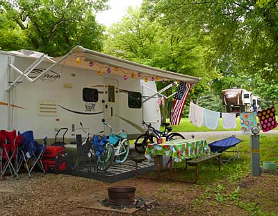
Most of the campers were friendly and many were with extended families.  There were loads of kids and dogs.  Maya actually enjoyed this more than we did.  By the end of the first day every kid in the place knew her name and said, “Hi, Maya,” every time they circled our campsite as they rode their bicycles around the campground. Maya was completely worn out by the countless pets and hugs from children and smells from other dogs.  By sunset the campfires were roaring and the sheer numbers of them in such close proximity filled the air with choking smoke.  All of us were happy to go to bed early.
 
A well-played game of chess
To Maya that means all the pieces have been rounded up and put in the corner
 

The playground, miniature golf course and swimming pool made the kids happy, but it wasn’t a true camping experience.  Camping in these sort of places is really more city than nature.  At least there was a pond where the kids could fish.  To be fair there are many definitions of camping and at a minimum the kids were outdoors, in a way…  On the plus side, we didn’t get any ticks, but we did see poison ivy.  I think maybe more than one kid went home with a rash.
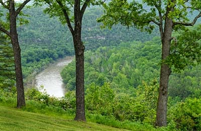
 
Cumberland Falls
 
Bright and early on Memorial Day we left the KOA behind and drove to Cumberland Falls State Park to finish our holiday with camping a little more our style – most of the crowds gone home and peace, quiet and nature all around.   

The beautiful Cumberland Falls, known as the ‘Niagara Falls’ of the south, is the showcase of the state park but there are several other falls and a network of trails too.  We had a leisurely afternoon strolling along the falls area and then later, a pretty sunset and a very peaceful night’s sleep – a nice way to end the Memorial Day Weekend. 
 
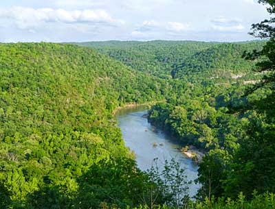
The Cumberland River along the Sheltowee Trace Trail
A very rocky river in places
 
The Sheltowee Trace is marked with a turtle sign
 

Still hoping for that long hike, the next morning we hiked a portion of the Sheltowee Trace Trail.  “Sheltowee,” meaning big turtle, was the name given to Daniel Boone when he was adopted as the son of the great Shawnee Indian warrior, Chief Blackfish.  At over 315 miles long, most of this trail is in the Daniel Boone National Forest of Kentucky with 45 miles in Tennessee.
 

One of the many 'tunnels' made by the rock cliffs along the
Sheltowee Trace Trail

David cools off in a small waterfall
 

The part of the Sheltowee Trace that we hiked followed the Cumberland River. That meant some climbing on the rocks and cliffs near the river bank – beautiful, but a bit of a workout.  The poison ivy wasn’t too bad so we kept at it until the heat and humidity took their toll.  And nobody got a tick!  All in all we managed over 6 miles which is our second longest hike so far this season.  Not that big of a deal compared to previous years on the trails, but we declared it a victory.
We were saddened to hear about the flooding in Texas and Oklahoma and concerned about all our friends and family there.  So far everyone we've heard from is fine but the rains are still coming.  You guys hang in there…

David’s Stats:

Days Hiked:  2     
Total Miles Hiked:  7.73   
Ave. Miles per Day:   3.87  
Total Elevation Gain:   1,110 
Ave. Elevation Gain per day:   555 


Mountain Laurel


A dogwood still in bloom near the falls


Sunday, May 24, 2015

An Emergence in Kentucky


The results of spring rain


We left the Buffalo River and Arkansas behind in pouring rain.  The good thing to say about all the rain is that everything is radiantly green.  Most of the plants would have a hard time finding room to fit in another leaf.   I’m sure the Ozarks are beautiful anytime, but this must be an exceptionally spectacular spring.  To West Texas eyes it is almost unbelievable.
 
New redbud leaves are so beautiful.
 
Since David and I lived in Missouri for 6 years, we decided that we wouldn’t spend a lot of time in the state this trip (although we are planning on stopping in St. Louis to visit friends on our way back to Texas).  So our only night in Missouri was spent at Lake Wappapello State Park on our way to Kentucky.  When we arrived we sat in the RV waiting for the rain to slow down enough for us to set up camp.  It did eventually let up and the sun even came out – just enough to make it a hot and muggy afternoon.  All that cool and rain most of the day and then we had to turn on our air conditioner.


Cicadas in various stages of emergence
Middle one is last stage instar nymph, left one is just beginning molt
and right one is a new adult with body starting to harden 
 

The next day near Paducah, Kentucky on Interstate 24, we stopped at a rest area and information center to pick up a state park guide and other travel brochures.  Going back to the car, David noticed the exuvia or exoskeleton ‘molts’ of cicadas clinging to the trunk of a great oak tree.  He pointed it out to me and we walked over to see an ‘emergence’ going on.  There were scores of cicadas still coming out of the ground, several molting ones on the tree bark with quite a few ‘hardening’ their new adult bodies on the trunk of the oak.  I’m sure many of the adults had already flown away judging by the number of molts on the tree.
 
New adult with old exoskeleton beneath it 
 
Sometimes referred to as locusts, the song of cicadas in summer months can be incessant and very loud.  As a child I can remember being made to take an afternoon nap and complaining that there was no way I could sleep with all that noise.  (Even though I didn’t want to take a nap, I still think I had a valid complaint.)

The cicada 'song' is sung by most male cicadas and they make the sound by flexing their ‘tymbals,’ which are organs on their abdomens.  Small muscles rapidly pull the drum-like tymbals in and out of shape, kind of like a click-toy.  The cicadas’ nearly hollow abdomen magnifies this sound to produce that well-known cacophony that can drive us all crazy during hot summer days and nights.


New adult just 'cracking' out of its exuvia or exoskeleton
Good things these guys aren't any bigger or they would be terrifying!


After a few photos David and I were back in the RV and on the road.  But we couldn’t stop thinking about cicadas. We remembered that some species emerge in large periodic cycles of 17 or so years.  We wondered if this was going to be a big emergence year.  So when we got a chance we did a little research and found that indeed, 2015 is going to be a remarkable year for periodical cicadas. 
 
After spending 13 or 17 years feeding in the ground,
 periodical cicadas tunnel out and climb on a tree or plant
 beginning the final molt to transform into adults


There are annual cicadas, too, that emerge in smaller batches every year but it is the periodical ones that tend to get our attention. Seven species of periodical cicadas, four with 13-year cycles and three with 17-year cycles, make up the genus Magicicada.  In the Midwest several of the species' ranges overlap.


Brand new adult cicada, just beginning to harden


According to Wikipedia and the website, magicicada.org, 2015 will have an emergence of all four of the 13-year periodical cicada species and all three of the 17-year.  If you live in certain areas where ranges overlap or are prepared for a little travel, you will be able see all seven described species of Magicicada.  Be prepared for a noisy summer!
 
One almost completely hardened adult and one about half way there
 

I normally don’t think of rest areas as being hot spots for nature, but you never know when or where you will find something to amaze you.  Nature is cool that way.   After playing ‘naturalists’ at the rest area we drove on to Pennyrile State Resort Park in the Pennyrile State Forest.  We chose this park because it has several miles of hiking trails in a beautiful state forest and we still entertain the hope of long hikes someday soon.
 
Are you sure you want to do this trail?
 

Curses, foiled again!  Poison ivy was the major villain this time although that is not to say that rain and ticks didn’t come into it.  We were so excited to take the Pennyrile State Forest Interpretive Tree Trail and learn more about mid-western trees.  It started out good, no rain and a relatively clear trail.  The signage was great and we were learning a lot.  But then the trail got narrower and soon poison ivy was everywhere. 

Determined to see it through to the end though, we did not give up.  Plus we had our Tecnu (poison ivy oil remover) with us.  We almost got lost a time or two as the trail was very overgrown and not well-marked on the last section but we made it back to the car as thunder rumbled in the distance.  Finally, we finished a trail even if it wasn’t a very long one.
 
I'd turn back if I were you...
Poison ivy in the trail
 

The poison ivy soap and Tecnu must be helping as so far neither one of us has had much of a reaction.   We both had a few little spots on our legs a week or so ago, but the spots were so insignificant that we weren’t sure if it was poison ivy.  (Considering how prevalent the ivy is this spring I can’t believe we have done so well.)  Inspecting Maya and taking very soapy showers back at the RV did reveal that there had been a few ticks on the trail too. 
 
 
Maya finds a big fungi


The rest of our time at Pennyrile was spent walking on wide trails around the campground and park roads.  Maya is tired of soapy baths and she has let us know this as of late...

 
David’s "Continually Pitiful" Stats:

Days Hiked:  2
Rain Days:    1    
Total Miles Hiked:  3.98   
Ave. Miles per Day:      1.99
Total Elevation Gain:     543
Ave. Elevation Gain per day:   272 


Friday, May 22, 2015

A Wild and Scenic River


Buffalo River near Buffalo Point Ranger Station
Buffalo National River, Arkansas


David and I are old ‘river rats’ from way back.  David’s graduation present from college was an Old Town canoe and we have spent many hours paddling white waters, mostly in Texas and Missouri.  Although we haven’t taken the canoe on our RV adventures so far, it is something we are thinking about for the future.  When the knees can’t hike as well, maybe the shoulders can still paddle.

When we lived in Missouri we spent hours floating on the Current and Jacks Fork Rivers in southern Missouri but never made it just a few miles farther south to the Buffalo River, America’s first national river.  Since we were going to pass right by Buffalo National River on our way to Kentucky, we thought we would stop a few days and investigate this river for future paddling trips. 


A rare moment of sunshine on the Buffalo River, near Buffalo Point


The Buffalo River has escaped dams, levies and other impoundments because in 1972 Congress designated it as America’s first national river.  This designation protects natural rivers from industrial uses and any other obstructions that “may change the natural character of the river or disrupt the natural habitat for the flora and fauna that live in or near the river.” 


Paddlers putting in the Buffalo at Dillard's Ferry
 

Because it has been such a rainy spring in much of Texas, Arkansas and the Midwest, the Buffalo was running high and swift when we arrived.  They were still letting people run the river but with the advisory that only experienced paddlers should attempt it.  We had thought about renting a canoe and taking a short section of the river, however we had never taken Maya in a canoe and didn’t have a life vest for her so we decided a high-water run was not a good idea.


Maya tries to bum a ride
 

As things turned out it rained a good portion of every day we were camped at Buffalo Point, one of the many campsites along the 135 miles of river that are administered by the National Park Service.  Watching drenched paddlers take out of the river near our campsite, slipping and sliding in the mud helped us feel better about not canoeing on this trip.  We entertained ourselves by taking a few of the trails around Buffalo Point between rain showers and then driving around the park and surrounding areas enjoying the beauty of the Ozark Mountains. 

One day we attempted to hike a section of the Ozark Highlands Trail, rated as one of the most scenic trails in the United States.  After a short drive we reached the trailhead.  By the time we had put our packs on rain drops were falling.  At ten feet from the car, I plucked the first tick off Maya.  An eighth of a mile into the trail and poison ivy completely covered it.  Any one of these things by itself might have been surmountable, but we decided we weren’t in the mood for all three together and so we turned back.  Maybe we just aren’t as tough as we used to be.  At any rate, reading in the rain in the RV was a more pleasant alternative.

 
Zebra Swallowtail


David’s Stats:

Days Hiked:  1
Rain Days:    3    
Total Miles Hiked:    2.95      
Total Elevation Gain:   351 


Monday, May 18, 2015

Devil Habitat


Entering the 'den' area
Devil's Den State Park, Arkansas


Perhaps you have never contemplated what might constitute ‘devil’ habitat and what the survival requirements of the horned one might be.  Well, spending a few days at Devil’s Den State Park has inspired me to give it some thought.  There would probably be no need for water, not sure what if any food would be necessary, high heat seems to come to mind whether the sun, geothermal features or both are the source is not known, rough rocks, dark crevices and caves for shelter would be needed and of course lots of space to enjoy it all.  But personally I would not have pictured the devil living in such beauty as we found at Devil’s Den State Park in the Boston Mountains of northwest Arkansas.


Crack in the sandstone rocks leading into a crevice 'cave'


Leaving the diverse plant and animal life and the springs and creeks out of the picture, the geology of Devil’s Den State Park does fit the name.  Lee’s Creek cut this beautiful valley through sandstone formations in the Ozark Mountains between 10,000 – 70,000 years ago.  Over time the creek removed enough sandstone to cause corners of the mountainside to break off, crack and slide causing jumbles of rocks and eventually creating many interconnected crevices and caves.  The effect today is a series of dark depressions, sandstone crevice caves and tumbled rocks tucked into a luscious valley of creeks and waterfalls – nice that there is a little of the Garden of Eden here too.
 
One of the 'Twin Falls' on the Devil's Den Trail


View of the Twin Falls


We had two days to explore the park and yes, we had to contend with what seems to be the 'norm' this spring – rain, poison ivy and ticks.  But fortunately none of them were bad enough to keep us from venturing out on the trails.  The park’s namesake trail, the Devil’s Den Trail, was by far the most spectacular.  The woods were dark and wet from the rain and overcast sky.  The trail and many rock formations were very slick.  Carefully we made our way over the slippery rocks in and out of formations called the Devil’s Theater, Devil’s Ice Box, Devil’s Den, the Crevices and the Bowls. 

One of the entrances down into the 'Devil's Den
 
Entering the 'Bowl' area
 
Once the trail reaches the ‘den’ area there are many places that these crevices can be entered and explored.  Because the caves are actually cracks in the rocks it is hard to get lost in them.  Many places in the caves are not in complete darkness due to the cracks that let in light from above.  Also these caves have walk in entrances and are mostly level so once inside there is no need for ropes.  For these reasons, Devil’s Den has been one of the few places that visitors can actually explore caves freely. 
  
Another of the unique formations in the park
 

Recently this policy has changed and the caves are now temporarily closed to entry.  Devil’s Den State Park is home to six species of bats, two of them being endangered species, the Ozark big-eared bat and the Indiana bat.  White Nose Syndrome (WNS), a very deadly disease to bats, has been rapidly making its way south from the northeast.  WNS is a fungus that is often observed on the nose of hibernating bats.  It is thought that the fungus kills the bats by disturbing them enough to awaken during hibernation thus using valuable fat reserves and weakening the bats so much that they cannot survive the winter.  Often 95 to 100 percent of the bats in a cave die.  Since it is not for certain how the fungus is spread and it is possible that humans could help the disease spread, caves are closed in this park and most of Arkansas for the protection of the bats. 
 
Plaque honoring the CCC's building efforts at Devil's Den
 

Hopefully more research will answer questions about WNS and bat populations will not be decimated.  We need bats – just one bat eats two refrigerators full of insects in a month.  Many of these insects damage or destroy crops such as corn and cotton.  So, however you feel about bats personally, you have to appreciate what this world would be like without bats eating all those insects.  If only bats ate ticks, but then ticks don’t fly (that really would be devil habitat…).


David’s Stats:

Days Hiked  1
Rain Days    1    
Total Miles Hiked    2.31
Total Elevation Gain    463  


Wednesday, May 13, 2015

High Points and well, ticks...


Maya summits Highest Point in Arkansas


Gentle rains have been with us off and on for our first full week back on the road, but during our last night at Petit Jean State Park thunderstorms and downpours were on the menu.  After a wakeful night we slept in a little and managed a leisurely breakfast in our RV during a break in the storms.  As we left the campground, the rain started up again and soon lighting and thunder were cracking all around us.  Good thing we hadn’t planned on going that far as 30 mph was our top speed for much of our trip to Mount Magazine State Park, about 60 miles to the west and north of Petit Jean. 
 
Cameron Campground on Mt. Magazine, morning fog
 
At 2,753 feet, Mt. Magazine is the highest point in Arkansas.  That doesn’t seem very high to us after our travels in the mountain west last summer, but saying that, it is hard to pass up the high point of a state.  And with all the recent rain, our decision to move to higher ground was beginning more and more to seem like a sound one.  Many of the streams and rivers in the immediate area were at or near flood stage.  At least we wouldn’t have to worry about flash flooding at our campground near the top of the mountain.


 Indigo Bunting taken near the Visitor's Center


As we drove up Mt. Magazine heavy with rain clouds, we were not treated to the views that this park is known for but we did catch a few glimpses of the valleys below and of the rain-swollen Petit Jean River.  We barely had time to explore the visitor center and set up camp before the rains came again. Another night of heavy rain and thunder marred our sleep.  


Wet trail to summit of Mt. Magazine


Morning dawned cool and very foggy, but only a light sprinkling of rain.  In case the weather deteriorated further, we decided a shorter hike would be best.  The trail up Signal Hill, the summit of Mt. Magazine, was across the road from our campground and only about a 3 mile round trip hike.  So off we went.  The trees at the top of the mountain were a bit stunted in their growth as the harsh conditions of being near the summit often create.  Branches were mostly bare as spring comes later to mountain tops.  The effect was an almost ‘spooky’ hike through the fog and mist to the top of Mt. Magazine. 


In many places the trail ran with water as it only had one way to go – down and into our boots.  The rocky, sandy soil kept the trails from being too muddy and we had only 300 feet left to climb to make the summit so the hike was really not that bad.  No one else was crazy enough to be out hiking and normally we like to ‘own’ the trails, but this day it was a little creepy being out in the fog alone.  Good thing we had Maya with us. 
 
Never encouraging when the trail sign points straight down
It means a hard climb back out
 
The next day was much nicer weather and we went on a longer hike enjoying some of the best scenery on the mountain.  With mostly sunny skies, we could actually see the views too.  The Bear Hollow Trail crossed 18 creeks!  Even with the heavy rains, most of the creeks were small and easily crossed.  We did get our poles out when we got to Big Shoal Creek though.  Extra points of contact are always helpful.


One of the many beautiful creeks we crossed on the Bear Hollow Trail

Eating lunch by the creek


The upper part of Bear Hollow has never been logged and contains some of the last remaining virgin hardwood forest in Arkansas.  Because spring was just arriving on the mountain and the trees were barely in leaf, we could see not only the great views but also the forest floor with its many new flowers and ferns starting to unfurl.  The poison ivy was present too, but much smaller and less of it, so we avoided it easily.
 
Sunrise Point from the Bear Hollow Trail
 
Don't look down!
 
We were feeling pretty good about our day although there had been a tick or two that we flicked off ourselves and Maya.  So when we got back to the campground we decided to do a serious search for ticks, just in case.  For the squeamish I don’t want to go into too much detail, but we lost count of the ticks we got off Maya somewhere in the 50s.  Most of them not attached, but crawling all over the poor puppy.  I think I got 5 or so off me and David around 10, again most not attached.  Maya has tick medication on her, so they do eventually die.  Still we did not want to bring the little crawlies into our RV if at all possible.  We did miss a few though as was evidenced this morning when we did further inspections.   And I think I’ll just leave it at that.


Red-spotted Purple Swallowtails (I think)
Some of the more pleasant insects on the trail


David’s Stats:

Days Hiked:  2
Rain Days:    1    
Total Miles Hiked:   9.60  
Ave. Miles per Day:   4.80  
Total Elevation Gain:   1,121 
Ave. Elevation Gain per day:   561 

Tick Count:  100+