Tuesday, May 28, 2013

On to Great Smoky Mountain National Park


Maya checking out the view near Clingman's Dome
in the Great Smoky Mountain National Park
 
After weeks of being so near the Great Smoky Mountains we finally made it into the National Park.   As we are ‘On the Road with Maya,’ staying in state parks and national forests gives us more options because Maya can hike with us there and she isn’t allowed on the trails in most national parks.  But that doesn’t mean we would pass up a great national park like the Smokies.  We understand that wild animals need protected places, too and we are glad they have them. So we spent more time in the car and less on the trails but we still had a wonderful time in the Smokies.


Spruce-fir forest near top of Clingman's Dome
Many of the Fraser fir are dying because of an insect attack


All of our national parks are special places but it is especially touching that the states of North Carolina and Tennessee worked so hard to help create the Great Smoky Mountain National Park.  In the 1920’s commercial logging was destroying the Appalachian forests. The citizens of North Carolina and Tennessee became alarmed and wanted to save some of their precious forests.  Most of the land that eventually became the Smokies was private land and had to be purchased and donated to the federal government.  So the people got busy and raised over half the money – even school children collected pennies and in 1934 the park was established.


Two room log home in the Cades Cove area of GSMNP
 
Larger farm and home in Cades Cove


Because so much of the GSMNP was private land, that meant many people were displaced from their homes.  Over two-thirds left the park.  A few were given lifetime leases on their places and some were given special permits to allow them to stay on and farm.  But the regulations in the park made it really hard to stay on.  People couldn’t hunt or cut firewood or even farm in the ways they had known since childhood.  Most eventually moved away and that was a sad thing.  Yet many of their farms, homes, barns, mills and churches are preserved in the park for their children and grandchildren and all of us to see how they lived in these beautiful mountains.  The park not only protects amazing Appalachian ecosystems but these historic structures as well.


Methodist Church with two doors, one for men
and the other for women and children

Church interior
 
I told David I must lack imagination because as I looked at where the farmers had made their homes and fields I would have never thought that it would be possible to build a house or grow corn on those steep slopes with all those rocks and trees.  Or maybe we are all used to much easier lives.  Life may have been simpler about 160 years ago when the Smoky Mountains were settled but there was nothing easy about it.


Our campsite at Elkmont Campground

Maya and David relaxing at camp


We spent 4 days at Elkmont Campground near the northern entrance of the park not far from Gatlinburg, Tennessee. We had a beautiful riverside campsite and neighbor campers from Texas.  Who would have thought we would have camping neighbors from Austin, TX right next to us?  Maya introduced us and we shared a few fires and s’mores and bear stories.  We were excited because all of us saw mama bears and cubs in different places in the park!


Maya and Melissa, her new friend from Austin
 
After four days of exploring the northern end of the park we left for an overnight trip to Knoxville, Tennessee for  some minor brake work on our Honda.  While we were there one of David's friends from AT&T was traveling through Knoxville on vacation with his wife.  So we arranged a lunch 'meet-up' with David W. and Sharon from San Antonio.  They had been having a great time in Kentucky and were on their way to South Carolina.  It was fun to catch up on all our travels and see friends from home. 


False Salomon Seal and Fern

Lady Slipper orchid


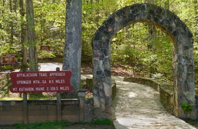
We hadn't seen all we wanted of the Smoky Mountains yet, so we headed back to the park.  The southern entrance to the park is right next to the Cherokee Indian Reservation.  Many of us forget that before our ancestors made the Smokies their home, these mountains were part of Cherokee territory.  The Cherokees have a rich history and many stories and legends centered in and around the park.  We spent the better part of the next three days exploring this part of the park, the town of Cherokee, NC and the nearby Blue Ridge Parkway. 


Tiger swallow tail butterflies getting some minerals from the soil
 
 
David's Stats: 
Days Hiked      5

Rain Days        2
Total Miles Hiked   9.07     
Ave. Miles per Day      1.81
Total Elevation Gain       2,100

Ave. Elevation Gain per day   420


Saturday, May 18, 2013

Trees, Tail of the Dragon and the Cherohala Skyway

Cheoah Point in the Nantahala National Forest, North Carolina

Santeetlah Lake at Cheoah Point
 
After leaving Georgia we entered into a couple of national forests – first in North Carolina and then Tennessee.  Often national forest campgrounds are remote and that was definitely the case for these two forests near the Great Smoky Mountain National Park.  We’ve been without phone or computer for over a week so a blog post is long overdue.

Joyce Kilmer Memorial Forest, North Carolina
 

"I think that I shall never see
A poem as lovely as a tree..."

Our first stop after leaving Georgia was in the Nantahala National Forest in North Carolina.  We stayed at beautiful Cheoah Point Campground on Santeetlah Lake south of the Smoky Mountains.  Just a few miles west of our campground and almost to the Tennessee border we discovered the Joyce Kilmer Memorial Forest which is located in over 17,000 acres of designated wilderness in a remnant of the original Appalachian forest.  The forest is named for Joyce Kilmer, the poet who wrote "Trees," that poem everyone memorized in elementary school.  Being a wilderness, hiking is the only way to see this beautiful old-growth cove forest with towering trees as old as 450 years.   
 
 
"...A tree that looks at God all day
And lifts her leafy arms to pray..."

Cove forests are located in sheltered valleys (coves) with deep, rich soils and abundant moisture.  They are some of the most biologically diverse plant communities in the world and where old-growth forests missed by loggers are most likely to exist.  We walked the two mile Joyce Kilmer National Recreation Trail and both agreed it was one of the most beautiful forests we had ever seen.

One of the 318 curves on US Hwy 129

US Highway 129 was the road we took to our next destination, the Cherokee National Forest in southeastern Tennessee on the edge of the Great Smoky Mountain National Park.  We did not realize what a famous stretch of road Hwy 129 was.  Named ‘Tail of the Dragon’ for its 318 curves in 11 miles, it may be America’s favorite two-lane tourist road.  It was pretty funny being on the road in our RV with all the Corvettes and Harleys passing us when they could.  Maybe if we had known what we were getting into we would have reconsidered and gone another route, but it was an amazing road and our RV handled it pretty well.  David’s quite the driver you know.  Maybe a sports car is in our future!
 

View from high on the Cherohala Skyway
 
Near white-out conditions on the Skyway
 
Once we finished our ‘grand prix’ on US Hwy 129 and crossed into Tennessee, we camped in the Cherokee National Forest at Indian Boundary Campground.  Indian Boundary is located about one quarter of the way on another amazing road, the Cherohala Skyway. The ‘Skyway’ crosses through the Cherokee and Natahala National Forests connecting Tennessee and North Carolina and its name comes from the combination of the two forests it passes through. 
There are places on the Skyway that are over a mile high and plenty of curves to be had as well.  The day we drove it, the weather made it a little scary.  It was raining and there were places we were in the rain clouds and almost in white-out conditions.  But then there were times we drove out of the clouds and rain and had some fairly clear views.  All in all it was an amazing drive.  Our week off the grid was sure filled with beautiful scenery, amazing trees and a few rather exciting drives.
David's Stats:
Days Hiked       3
Total Miles Hiked   7.52   
Ave. Miles per Day      2.51
Total Elevation Gain       674
Ave. Elevation Gain per day  225
 
Smoky Mountains
 

Thursday, May 9, 2013

Rainy Nights and Days in Georgia


Misty, foggy, windy hike on the Appalachian Trail

The Blue Ridge Mountains looking blue in the rain...

Rain falling on our RV – it is becoming an all too familiar sound.  For the last two weeks it has rained almost every night.  A few nights ago after a heavy rainfall at our campground in Unicoi State Park we were awakened in the early hours of the morning by a cracking sound and then a loud crash to the ground.  It sounded really close but we didn’t feel the RV move so we went back to sleep.  The next morning David and Maya found a fallen tree only 50 yards from us but on the other side of the road.  A medium sized Eastern White Pine had lost its grip on the sloping ground and fallen cracking a Red Maple and taking about 1/3 of the top of the maple with it.  It wasn’t even a close of a call but of all the things that can happen, we never think about a tree falling on us while we are sleeping.  And that’s probably a good thing…

Trillium blooming on the AT


Rain slick rock on the AT
 

We are still getting in some hiking but the rain has slowed us down.  Yesterday we hiked a gorgeous trail to Raven Cliff Falls that followed a winding creek lined with rhododendrons just starting to bud.  It was a fairly easy trail but the rain made the rocks slippery and in the final ascent to the falls we had to walk ever so carefully.  David had a little slip on the rocks and smashed his thumb but besides hurt pride and a throbbing thumb he was fine.  Maya is such the ‘mama’ dog that anytime either one of us makes a noise like we might be hurt she runs over and starts licking us and whining. So David got plenty of attention from Maya and that made him all better.


Raven Cliff Falls

 Concerned Maya

We also hiked on the Appalachian Trail a little more but not as much as originally planned.  The fog, rain, gusting winds and slick rocks made the going a little harder.  Again we thought of those hikers we had met and wondered how they were doing on the AT.  Hikers often have to keep on going no matter the weather because they only have so much food and have to get to the next town for more supplies.


Dwarf Crested Iris on Raven Cliff Falls Trail

Another fun hike we did in the rain was Anna Ruby Falls.  Two creeks come together at Anna Ruby Falls making two falls that tumble down to form Smith Creek.  The waterfalls are always an awesome sight but because of all the rain, the creeks were almost at flood stage causing the falls to be flowing much more than usual. 
 
Anna Ruby Falls
Smith Creek below Anna Ruby Falls
 
After 5 nights at Unicoi State Park we gave up on the rain giving up and traveled a short distance to Tallulah Gorge State Park to spend our last night in Georgia.  Tallulah Gorge is a spectacular canyon at two miles long and nearly 1,000 feet deep.  We hiked the rim trails to the several overlooks and enjoyed the views into the very rugged and beautiful gorge.  Usually permits are available to hike down into the gorge floor, but because of the weather no permits were being issued.  There is a suspension bridge 80 feet above the rocky bottom and almost 900 feet down into the canyon.  We didn’t make the climb down but heard from a fellow camper that it was well worth the trip. Maybe on our way back this fall...


Tempesta Falls, South Rim Tallulah Gorge


David's Stats:
Days Hiked      4     
Total Miles Hiked     19.14      
Ave. Miles per Day     4.54     
Total Elevation Gain      3,632     
Ave. Elevation Gain per day     871  

Rain outs (no hiking days)      2  

Saturday, May 4, 2013

Blood Mountain and Vogel State Park, Georgia


Lake Trahlyta at Vogel State Park

We left Amicalola Falls State Park in a light drizzle and moved about 44 miles east and north to Vogel State Park, our next ‘base’ for hiking on the Appalachian Trail.  Vogel State Park is nestled in the Blue Ridge Mountains in the shadows of Blood and Slaughter Mountains and it is one of the richest botanical areas in Georgia.  Just above the park the Appalachian Trail summits Blood Mountain which is the highest point on the trail in Georgia.


Byron Herbert Reece Nature Trail at Vogel
More types of trees grow here than in Yellowstone National Park.


Before the white man came to Georgia, this was Cherokee Indian territory. One legend of how Blood Mountain got its name is that there was a fierce battle between the Creek and Cherokee nations just above present day Vogel State Park between Blood and Slaughter mountains.  The battle supposedly raged so long and fierce that the streams at the foot of the mountain ran red with blood.


Iron stained stream at base of Blood Mountain
 

Red lichen growing on rocks on Blood Mountain
These may be other reasons for the name, Blood Mountain.
 
Wolf Creek runs through the park and campground and empties into Lake Trahlyta which was constructed in the 1930’s by the Civilian Conservation Corps.  It is absolutely amazing to us just how many state parks nationwide have at least some structures, trails or lakes built by the CCC.  Where would our parks be without the CCC?

After arriving at the park and setting up camp, we hiked around Lake Trahlyta and to the small falls below the lake.  The reflections of the Blue Ridge Mountains in the small lake were just gorgeous.  It was a good thing we stretched our legs a bit because the next day it rained hard all day long.  We were thankful for the luxury of staying dry in our camp and reading all day unlike those hikers we had met out there on the AT.


Lake Trahlyta from the Bear Hair Gap Trail
 
The next two days were beautiful and we took full advantage of them, hiking first the Bear Hair Gap Trail in the Blood Mountain Wilderness and then heading up to hike on the Appalachian Trail via the Freeman Trail to Blood Mountain.  Both hikes climbed through mostly hardwood forests that were just beginning to leaf out at the higher elevations.  And both of them gave us a good workout – lots of up and down.  David and I are looking forward to getting our mountain legs back someday.  We thought the east would be easier than the west because of the lower elevations and it is – on the lungs, but not so much on the legs.


Blood Mountain Shelter built by the CCC 
Many hikers use the shelters along the AT and most of them are located near water.
 
On our trek to Blood Mountain we met some more Appalachian Trail hikers and “thru-hikers.”  First there was ‘Grandpa’ from Kentucky.  Lots of AT hikers give themselves trail names and that is what people know them by on the trail.  Grandpa was a solo hiker about David’s and my age and he was hiking a portion of the AT, about 220 miles of the trail from Amicalola to Gatlinburg, Tennessee.  He had allowed himself about 22 days to do it and he was meeting his golfing buddies (none of whom wanted to hike with him) for their yearly golf game in Gatlinburg.  I don’t know if he will beat his buddies at golf but he should be able to walk their socks off on the course.


Maya enjoying view from top of Blood Mountain
 
We had just summited Blood Mountain and were sharing lunch and a view with Grandpa when a young couple and their two dogs came down the trail.  Maya was happy to meet some of her own kind out hiking and we all spent a few minutes talking (and sniffing).  The couple (I wish I had asked their trail names) had started the AT a few years back and had to quit after 500 miles but they were confident they would make it this time.  The young woman was struggling a little bit with blisters on her feet as they had walked in wet boots after that really rainy day that David and I spent in the warm and dry RV.  Other than blisters they were doing great.  But Blood Mountain is just 37.8 miles from their starting point at Amicalola Falls. They had only been on the Appalachian Trail for 4 days.


Serviceberry blooming on Blood Mountain
Legend has it that the tree bloomed about the time when the circuit riding preachers got out to conduct the first services of the year in early spring, hence the name serviceberry.
 
We finished our lunch and said goodbye to Grandpa and started our descent down Blood Mountain heading for the Walasi –Yi Inn, a hikers’ hostel, grocery store, mail drop and backpacking shop right on the Appalachian Trail.  This wonderful CCC building is privately leased from the Forest Service and run by ardent AT supporters.   And did I mention that the trail really does go right through the building? 
We caught up with the young couple and their two dogs at Walasi –Yi.  They were picking up their first food and supply shipment at the mail drop (most AT hikers have supplies sent to themselves along the trail) and were going to hike on a little farther down the trail and cook meat over a fire for dinner.  We decided that cooking meat over a fire for dinner did sound like an excellent idea, so we headed back to our camp to do just that.


Hiking Boot Tree at Walasi-Yi Inn on the Appalachian Trail


David's Stats:
Days Hiked    3  
Total Miles Hiked     17.07 
Ave. Miles per Day      5.69
Total Elevation Gain       3,383
Ave. Elevation Gain per day   1,128


One day of heavy rain where we stayed in the RV.


Wednesday, May 1, 2013

On to Georgia - Amicalola Falls State Park

Northern Georgia

After our slow-paced time on the Natchez Trace Parkway, we got back to 'life in the fast lane' on the state highways and freeways of Tennessee.  We spent a night in a commercial RV park just outside Chattanooga, TN and then we headed over to northern Georgia to Amicalola Falls State Park near the southern terminus of the Appalachian Trail. 


Amicalola Falls

David and I have only been to Atlanta and have not traveled in Georgia at all.  We weren't prepared for how gorgeous northern Georgia is.  Mossy rocks and trees, everything is so green.  It almost felt like the temperate rainforest of the Oregon coast. The Appalachian Mountains begin here and the Blue Ridge Mountains too.  Curving and climbing roads slowed us down again as we made our ascent.  It was hard work for our RV engine, so a good thing we got everything fixed in Jackson.
 
The Appalachian Trail Approach at Amicalola Falls State Park
Mt. Katahdin, Maine only 2,108.5 miles!
 
The official southern terminus of the Appalachian Trail is atop Springer Mountain and it is accessible only by foot. There is a trail to Springer Mountain from Amicalola Falls State Park.  Many hikers stay in the state park and take the AT Approach Trail to Springer Mountain.  That adds another 8.5 miles to the 2,108.5 mile journey if you were going to hike the whole trail all the way to Mt. Katahdin, Maine.  Needless to say, David and I aren’t – not this trip anyway.  But we are going to hike lots of little sections of the AT as we make our way north this spring and summer.


Another way to start on the AT is to take US Chattahoochee Forest Road 42 to the Springer Mountain Trailhead and then hike the one mile south to Springer Mountain. As you retrace your steps back down Springer Mountain, you have officially started on the Appalachian Trail.   We talked to a couple who had just hiked Springer Mountain with their son who was planning to “thru-hike” the AT alone.  The three of them had walked up and back down Springer Mountain together with their little dog and then they had said goodbye as their son continued on from the Springer Mountain Trailhead heading off to Maine.  I could tell the parents were having a little bit of a hard time, especially mom.
 
Maya at Springer Mountain, the official southern terminus of the AT
 
Our friends Sasha and KC have thru-hiked the Appalachian Trail and they have said it is surprising how many people do hike it alone or at least start the trail alone.  So many people are on trail every year that there is an AT Trail “community” and people on the trail are very friendly and helpful to each other.  There are state parks, lodges and towns on or near the AT so there are lots of opportunities to get supplies, eat a good meal, make a phone call or even take a few days off to rest and take a hot bath in a lodge.  Still, what an adventure and a commitment!  Basically you are hiking for 4 or 5 months in sun, wind, rain and maybe even snow.  Those that make it can be proud of that accomplishment and have stories to tell for the rest of their lives.


Dwarf crested iris along the Approach Trail
 
 
Mayapple and immature Yellow-poplar trees along the AT


On a much, much smaller scale David and I did hike to Springer Mountain, although in phases.  We could have made the 8.5 miles fairly easily from Amicalola Falls but then we would have had to hike back since we aren’t backpacking and don’t have tents and sleeping bags with us on this trip.  Seventeen miles was just a bit more than we wanted to hike in a day especially climbing a mountain.  So we took the Forest Road to the Springer Mountain Trailhead and hiked the beginning of the AT.  We also hiked a good portion the AT Approach Trail from Amicalola Falls.
 
Top of Amicalola Falls
 
At 729 feet, Amicalola Falls is the tallest cascading waterfall in the Southeast. The park is very popular with AT hikers and provides a parking lot to leave cars while the trail is being hiked.  There is a nice lodge at the top of the falls where David and I ate dinner in the clouds one evening. The beautiful campground is also near the top of the falls and the road going up  is a 25% grade.  Not for those with a faint heart...


David's Stats for Amicalola:
Days Hiked    2  
Total Miles Hiked     15.84 
Ave. Miles per Day     7.13
Total Elevation Gain     3,659 
Ave. Elevation Gain per day   1,775

One rainy day where we did not hike but 1.6 miles.