 |
| Northern Georgia |
After our slow-paced time on the Natchez Trace Parkway, we got back to 'life in the fast lane' on the state highways and freeways of Tennessee. We spent a night in a commercial RV park just outside Chattanooga, TN and then we headed over to northern Georgia to Amicalola Falls State Park near the southern terminus of the Appalachian Trail.
 |
| Amicalola Falls |
David and I have only been to Atlanta and have not traveled in Georgia at all. We weren't prepared for how gorgeous northern Georgia is. Mossy rocks and trees, everything is so green. It almost felt like the temperate rainforest of the Oregon coast. The Appalachian Mountains begin here and the Blue Ridge Mountains too. Curving and climbing roads slowed us down again as we made our ascent. It was hard work for our RV engine, so a good thing we got everything fixed in Jackson.
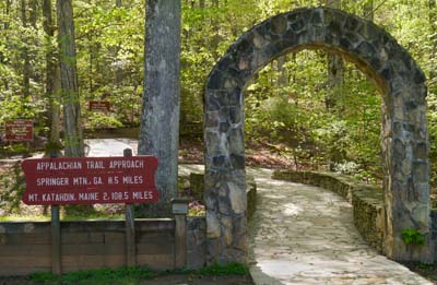 |
| The Appalachian Trail Approach at Amicalola Falls State Park Mt. Katahdin, Maine only 2,108.5 miles! |

Another way to start on the AT is to take US Chattahoochee Forest Road
42 to the Springer Mountain Trailhead and then hike the one mile south to
Springer Mountain. As you retrace your steps back down Springer Mountain, you
have officially started on the Appalachian Trail. We talked to a couple who had just hiked
Springer Mountain with their son who was planning to “thru-hike” the AT
alone. The three of them had walked up
and back down Springer Mountain together with their little dog and then they had said goodbye as their son
continued on from the Springer Mountain Trailhead heading off to Maine. I could tell the parents were having a little
bit of a hard time, especially mom.

Maya at Springer Mountain, the official southern terminus of the AT

Dwarf crested iris along the Approach Trail

Mayapple and immature Yellow-poplar trees along the AT
On a much, much smaller scale David and I did hike to
Springer Mountain, although in phases.
We could have made the 8.5 miles fairly easily from Amicalola Falls but
then we would have had to hike back since we aren’t backpacking and don’t have
tents and sleeping bags with us on this trip.
Seventeen miles was just a bit more than we wanted to hike in a day
especially climbing a mountain. So we
took the Forest Road to the Springer Mountain Trailhead and hiked the beginning
of the AT. We also hiked a good portion the AT
Approach Trail from Amicalola Falls.

Top of Amicalola Falls
David's Stats for Amicalola:
Days Hiked 2
Total Miles Hiked 15.84
Ave. Miles per Day 7.13
Total Elevation Gain 3,659
Ave. Elevation Gain per day 1,775
One rainy day where we did not hike but 1.6 miles.
No comments:
Post a Comment