Sunday, June 30, 2013

Harpers Ferry

Harpers Ferry stores

We came out of the Blue Ridge Mountains and Shenandoah National Park at the northern park boundary near Front Royal, Virginia.  Our plan was to head to Harpers Ferry and then on to Gettysburg.  Both historic sites were right on our way north and on our list of places we really wanted to visit.

 Supply Wagon for the U.S. Armory at Harpers Ferry

We stayed in a commercial campground just outside of town near Harpers Ferry, West Virginia.  The first thing we noticed is that we weren’t in the cool mountains anymore.  Summer had arrived for the Sims Family.  The humidity was really high so for the first time in over a year we slept with the air-conditioner on most of the night. That almost never happens as we are usually in places where we can open the windows at night and if needed, use the fan.


White blaze on light post marks the Appalachian Trail
 
 
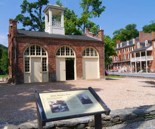
The next morning we walked with Maya into Harpers Ferry from the visitor center.  The cool of the morning made it a nice walk, but the promise of a hot day was already in the air.  We visited most of the town’s historic places, from John Brown’s Fort to Harpers Ferry water gap where Thomas Jefferson commented upon seeing the confluence of the Shenandoah and Potomac Rivers crashing together as “perhaps one of the most stupendous scenes in Nature.”  The Appalachian Trail goes right through Harpers Ferry so we followed the trail markers, white blazes on the lamp posts in town.  We saw a few AT hikers taking a rest and enjoying visiting the town.
 
John Brown's Fort
The armory fire-engine house came to be known as
John Brown's Fort as he was eventually captured there
 
Harpers Ferry has a complex history.  Most of us remember it for John Brown’s attack on slavery and the town’s strategic location during the Civil War causing it to change hands between north and south occupation eight times.  As we toured the town and its fantastic exhibits in the different historic buildings we learned so much more about Harpers Ferry. 

Many famous Americans had part of their roles in American History take place in or near Harpers Ferry – George Washington, Thomas Jefferson, Meriwether Lewis, Robert E. Lee, J.E.B. Stuart, Stonewall Jackson, Abraham Lincoln, George Armstrong Custer and Frederick Douglass just to name a few of the most famous.  One of the pleasures of aging is to re-examine the things you learned long ago and to discover new insights and understandings.  Learning is fun at any age, especially if you are standing right in the place where it happened.

Ruin of St. John's Episcopal Church which also served
as a hospital during the several Civil War Battles at Harpers Ferry


David's Stats:
Days Hiked       1
Total Miles Hiked       3.5  
Total Elevation Gain       360   


Friday, June 28, 2013

Shenandoah National Park

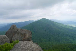
Blue Ridge Mountain view from the Skyline Drive

Our time on the Blue Ridge Parkway was over, we had reached the northern terminus. But on the bright side, Shenandoah National Park stretched before us with its own scenic roadway, the 105-mile Skyline Drive beckoned us onward.  One magnificent parkway ended but we still had some more ‘slow road’ to explore and a whole national park we had never visited.
 
Lunch time near Cave Creek Falls, David and Maya were dwarfed by the large boulders 

Spanning the crest of the Blue Ridge Mountains, the historic Skyline Drive is the only public road through Shenandoah National Park.  Construction of the Skyline Drive began even before Congress established the national park.  It was to be Shenandoah’s single greatest feature, a road to the top of the Blue Ridge Mountains back when skyscrapers and air travel were not commonplace.
 
Rose River Falls


Along the Rose River Loop Trail
 

Like the Great Smoky Mountain National Park, many families lived in what would become Shenandoah.  The park was formed from over 1,000 privately owned tracts of land – a patchwork of forests, fields, orchards and home sites. Times were very hard in the early 1930’s and over half of the people had already moved from the area.  There was the depression and then there had been a serious drought and crop failures.  The chestnut blight had killed the majority of the chestnut trees by then so a prime source of income was gone.  Many of the remaining farmers were hired to help build the Skyline Drive after the crop failures.


A foggy morning at our campsite near Big Meadow


The park opened in 1935 and Skyline Drive was finished in 1939 during Roosevelt’s administration with most of the picnic grounds, comfort stations and overlooks built by the Civilian Conservation Corp. (Those CCC boys again!)  There are also more than 400 buildings and structures along the Skyline Drive that are listed in the National Register of Historic Buildings as representative of the “best of the 1930’s.”  From President Hoover’s Rapidan Fishing Camp to the Skyland Resort established in the late 1800s, the park is full of historic structures to visit.  It is no wonder that Shenandoah National Park soon became everyone’s mountain retreat, a place to escape summer heat and urban life.  

Maya and David barely visible on our Cedar Run/White Oak Loop hike
 
The fog created a forest full of mystery and magic


There are four campgrounds in Shenandoah and we decided to stay at the largest, Big Meadow, because it was about mid-way through the park and that made a convenient ‘base camp’ for us to explore.  The park has over 500 miles of hiking trails with over 100 miles being part of the Appalachian Trail.  It was also so nice that Shenandoah is one of the rare national parks where dogs are allowed on most of the trails, so Maya went hiking with us every day.


Cedar Run Trail
 
One of the many cascades on the Cedar Run Trail
 

Two beautiful, sunny days bookended our stay in Shenandoah.  In between it was rainy and foggy with one day having dense fog well into the afternoon.  One thing about being in a park where the major road follows the crest of the mountains – that means just about every trail descends rather steeply and then you have to climb back up.  One trail in particular, the Cedar Run/White Oak Loop, was over 10 miles long and 2,598 feet of elevation gain.  Thank goodness it was a cool day, although a bit humid.  I hate to think how much I would have “glowed” if it had been warmer…  We were all a little tired at the end of that day but I do think it was the prettiest hike we took in the park.  It was made extra lovely by the dense fog that morning. The woods were magical.


Stream crossing on White Oak Creek
Maya always does better than David and I - she doesn't mind getting all wet
 
After the crossing
 
 
One day we had a very cool surprise.  After a fairly strenuous hike we thought we deserved something cold to drink or maybe some ice cream so we stopped at the Big Meadows Wayside on our way back to camp. There sitting at one of the tables in the restaurant, were friends of ours from San Antonio, Texas, Judit and Carl Green and their two children.  They were on vacation and camping at the park in a different campground.  It was so good and unexpected to run into ‘folks from home.’  We just never see anyone we know out on the road unless we have planned to meet.  We had a nice visit, compared notes on our various activities and Judit treated us to ice cream and blackberry cobbler.   What a good day!
 
The Green Family with Maya
 
A rare family portrait - Thanks Judit!
 
David's Stats:
Days Hiked      4
Total Miles Hiked   26.33     
Ave. Miles per Day      6.43
Total Elevation Gain       5,684
Ave. Elevation Gain per day   1,395


Lower White Oak Falls
 
Another view of Lower White Oak Falls
 

Upper White Oak Falls


Sunday, June 23, 2013

The Blue Ridge Parkway -- Virginia


No mystery why they call them the Blue Ridge Mountains...

After our amazing time at Grayson Highlands State Park we made our way back to the Blue Ridge Parkway to follow it up to Shenandoah National Park.  We spent nearly a week traveling the last 200 miles of the Parkway staying at two campgrounds along the way – Rocky Knob and then Peaks of Otter.  Both campgrounds had many trails leading from them and made good places to stay as we explored more of the Parkway.
 
Parkway sky near  Rocky Knob
 
Mabry Mill near Rocky Knob with rhododendron still blooming
 
We hiked the better part of several days and even caught up a little on our reading on a couple of rainy afternoons.   Slowing down to travel like this is a luxury that we’ve never had before; spending a week to travel 200 miles when it used to be more like 2,000 miles in a week.  No hurrying to make the next plane or tour, no Internet and maybe a bar or two of phone service on the highest points.  Parkway-style travel could definitely get in your blood.
 
Old chimney still standing on Black Ridge Trail
 
 
'Fire Pink' blooms in May and June at higher elevations
 
 
The Virginia section of the Blue Ridge Parkway was just as scenic and beautiful as the North Carolina section.  It wasn’t quite as high in elevation so much of the rhododendron had already bloomed in Virginia.  But the mountain laurel was gorgeous along many trails.  Summer flowers were starting to bloom in places and it was getting a little warmer.  Nights were in the low 60’s and days in the high 70’s to low 80’s – not bad considering my parents in Texas have had several days in the 100’s already.

 
Mountain laurel in full bloom
 
Tree fungi - decomposers can be beautiful too


Traveling along the Parkway has been a continual change in seasons, sometimes in a matter of minutes.   At higher elevations it was early spring and then in the lower elevations it was summer.  In a few hours on a trail you could go from summer to spring and back again. 
James River
 
View from Sharp Top Mountain near Peaks of Otter
 
 
We did see some of the effects of sequestration.  The campground at Rocky Knob was partially closed.  We didn’t have any trouble finding a place to camp but we were there during the week.  Weekend campers might not be so lucky.  Also, the visitor center and picnic grounds at James River were closed.  Three campgrounds of the nine along the Parkway were completely closed as well as several picnic areas and restrooms. Maybe camping and vacationing seem like luxuries that could be ‘cut back on’ but we hated to see our nation’s parks not being staffed and cared for as well as they could be.  Our parks are the jewels of our nation, a source of pride and our source as well.
 
Visitor Center Closed -- sequestration effects...
 
David's Stats:
Days Hiked   4

Rain Days     4   
Total Miles Hiked   16.02     
Ave. Miles per Day      3.8
Total Elevation Gain       3,655
Ave. Elevation Gain per day   894


'Monster Rock' on the trail near Rocky Knob


Saturday, June 22, 2013

Cabin Creek Trail, Grayson Highlands State Park


Foggy morning on the Cabin Creek Trail
 
 
The weather forecast for the next several days was more rain and fog in the mountains, so we gave up on any ideas of more hikes up into pony territory.  However we did take one more beautiful hike while at Grayson Highlands State Park. 
 

Spooky Tree

The Cabin Creek Trail started in the same area as the trails into the high country but it stayed down in a little valley drained by Cabin Creek.  The trail wound through a densely wooded rhododendron forest and then the canopy opened up slightly into a thick hardwood forest.  Although it was not as ‘socked in’ as it was higher in the mountains, it was very foggy, dark and almost spooky.  We were enveloped in mist and quietness which served to heighten our senses. 

Bear scratches on birch tree 


There was a yellow birch tree that had long claw marks down its bark, no doubt a message left by a bear.  Thank goodness the trail was easy to follow; it was not a good day to be lost in the woods.
 
Flame Azaleas
 
 
About the time we reached the falls, the fog had started to clear a bit and our trip out of the valley was a little brighter.  The flame azaleas were blooming profusely and splashes of orange and yellow were everywhere.   Maybe it wasn’t ponies, but it was gorgeous and not a bad way to spend our last day in the park.


Nearing the falls

Cabin Creek Falls

Sunday, June 16, 2013

Grayson Highlands State Park, Virginia


View of Mount Rogers and Wilburn Ridge from the top of  Little Pinnacle

After enjoying 6 out of 7 days of clear weather, it looked like rain was headed our way again.  But rain or not both David and I had been looking forward to our next side trip off the Parkway.  We were headed into the southwestern corner of Virginia to Grayson Highlands State Park. 
 
Clear view across Grayson Highland from Big Pinnacle, a rare sight
 
The park is flanked by the two highest peaks in the state, 5,729-foot Mount Rogers and 5,520-foot Whitetop Mountain.  Truly a high land, Grayson Highlands is the realm of the clouds, spruce-fir forests, flower-dotted balds grazed by wild ponies, miles of hiking and horse trails plus a section of the Appalachian Trail.  After our wonderful AT hike at Roan Mountain we were anxious to hike again in spruce-fir forests and balds and, OK, I admit it - I am a sucker for horses.
 
Maya, our trail finder in the fog...


We arrived at the park around noon, set up camp and hurried out for a quick hike as the rain was fast on its way.  The Twin Pinnacles Trail had been recommended to us by fellow campers at Stone Mountain (Maya’s dog friends, Lulu and Star’s owners) as a great trail to take to get a good view of the park.  The clouds were rolling in, but it was still clear enough to get good views of Mount Rogers and Wilburn Ridge.  As it turned out it was a very good thing we went when we did. The views quickly disappeared into clouds not to return again while we were there.
 
Ponies in the mist...

The next day fog clung to the trees and mist dripped from everything.  But we were still determined to take our hike up near Mount Rogers.  One thing we have learned is that you can be ‘socked in’ at one location and a short distance away, things can be much clearer.  So with all our rain gear either on our bodies or in our packs we headed up the Rhododendron Trail to the Appalachian Trail and then to Mount Rogers just outside the park in the Jefferson National Forest.
 
Mare near foaling time
 
 
Paint stallion

The weather went from rain to barely misty to fairly clear and back – over and over again.  There were times we could barely see 10 feet in front of us and times we could see about half a mile.  Everyone had told us that the ponies had been seen but not to count on it as they often remain hidden in the forests or the high brush.  We thought they could be right in front of us and we might not be able to see them because of the fog.  During some good visibility on the first half of our hike we spotted a mare and young colt at a distance and were thrilled to see them.  They were far away so I didn’t get good photos but we were just glad that we got to see them.


But then on the way down from Mount Rogers our luck went from so-so to amazing.  We saw four separate bands of ponies each with a stallion, several mares, yearlings and young colts.  Two of the bands were at a distance but we got very close to the other two bands.  The ponies are wild and the park encourages visitors not to approach them or feed them.  But they have become accustomed to people and aren’t disturbed if you walk calmly around them (and many AT hikers do).
 
 
The ponies are not native to the park.  Throughout North Carolina and Virginia in the ‘bald’ areas of the Appalachians and Blue Ridge Mountains, different techniques have been used to keep the balds bald.  Mowing, burning and the introduction of grazing animals have all been used.  In the 1970’s, the Wilburn Ridge Pony Association was formed. They bought ponies and released them at Grayson Highlands and the Mount Rogers area to graze the balds.  It has been working well although some of the balds are being invaded by high brush that the ponies have not been able to graze down.  Every fall, the pony association holds a round up and sells some of the excess ponies to keep the herds healthy and the population stable for the land available.
 
Stallion in the mist
 
One of the bands of ponies we passed close to had a couple of young foals.  The herd was right in the trail and we slowly walked by being careful not to upset the moms.  But one of the foals thought that Maya was just the perfect size for a playmate.  It was just precious how curious and how much the foal wanted to get close to Maya.  Finally we just gave us and let them sniff noses.  But little ponies and herding dogs don’t really speak the same language and we did not let the games begin. 


New buddies...
 
As David and I were watching our little band of ponies (I called them ours because we spent so much time with them), we were privileged to see a drama unfold before us.  Another band of ponies ran by us and the two stallions challenged each other.  It was getting incredibly foggy as all this was taking place, so David and I couldn’t see everything.  It appeared to us that the stallions were equally matched and that mostly a lot of posturing was all that happened.  But as the second stallion and his band moved on, one of his mares slipped away and remained with ‘our’ band and stallion. 
 
The new mare (on the right) with 'our' stallion
 
 
The band stallion staying close to the new mare

Our stallion was very happy to have a new mare but his mares were not too sure about the new girl.  A lot of sniffing and some biting and chasing went on.  It was getting later and foggier and we had been watching ponies a long time, so we headed back to camp before we were sure of the outcome.  I like to think the new mare was accepted. 
 
 
Another mare about to foal
 
It would have been fascinating to stay for weeks or even months watching the herds and seeing their lives unfold.  We were going to hike back up the next day to see if we could see ‘our’ band of ponies again, but thunder storms and flash flood warnings made that impractical.  Still, we felt incredibly fortunate to have seen four bands of ponies and to get to spend such a long time with one. 


David's Stats:
Days Hiked       2

Total Miles Hiked    12.25     
Ave. Miles per Day      6.13
Total Elevation Gain       2,181
Ave. Elevation Gain per day   1,091