Tuesday, September 23, 2014

A Great Bear and a Fall Jewel


Bear Creek, Great Bear Wilderness, Montana


Fall color on the Big River Trail, Great Bear Wilderness


After crossing back into the United States at Chief Mountain our plan was to stay at a campground in the Flathead National Forest right on the border of Glacier National Park.  But when we arrived we found that the campground was closed for the season.  Many forest campgrounds close early in the northwest.  As our time in Canada proved this year, snows can come early!  Luckily we found a nice commercial campground only a few miles away that suited our needs perfectly.  We were relieved as we had been looking forward to hiking in the Great Bear Wilderness, our 20th wilderness to visit so far this year.

 
Thimbleberry in fall color


Located west of the Continental Divide, the Great Bear Wilderness is south of Glacier National Park across US Hwy 2 and shares its southern border with the Bob Marshall Wilderness.  Montana’s wildest river, the designated ‘wild and scenic’ Middle Fork Flathead River, has its origination point in the Great Bear and runs 50 miles through the wilderness.  The 286,700 acres of the Great Bear are prime grizzly and black bear habitat.

 
The forest floor was full of mushrooms


Our trail was called the Big River Trail and it crossed Bear Creek, then climbed above and loosely followed the Middle Fork Flathead River deep into the wilderness for over 25 miles.  We only hiked in about 4.5 miles to a quiet spot high above the Middle Fork Flathead River where we had a nice lunch enjoying the quiet beauty, solitude and beginnings of fall color.  Although we hiked close to 9 miles, we left the wilderness refreshed and rejuvenated. (OK, so maybe not our leg muscles…)  Except for the two fishermen we saw at Bear Creek, we saw no one.  It was truly a wilderness experience.

 
Splashes of fall color on the slopes of the Jewel Basin


Rain fell during the night and the next morning we woke to overcast skies and drizzle.  Since the forecast was for rain all day, we decided to move on to Kalispell and wash all our clothes after almost 3 weeks in Canada.  Things were getting pretty rank…

 
Twin Lakes Trail


While we were cleaning up in Kalispell, we took one day off for another hike in the Jewel Basin.  We enjoyed our hike there a month ago so much that we wanted to take another one.  This time we skirted the basin on the west side taking the Twin Lakes Trail into the basin.  While the views weren’t as spectacular as they were from our first hike up Mt. Aeneas, it was still a very scenic trail. 
 

The Twin Lakes
 
North Twin Lake
 
 
The clouds and fog were heavy for most of the day but we could still see across the basin and glimpse the tops of the peaks through the fog.  The vine maples, sumac, thimbleberry and huckleberry were already a riot of color.  I am predicting an early and colorful fall here in the northwest.   I don’t know if it is the cooler weather, the excitement of fall color or the fact that the trails are mostly deserted because vacation time is over – but whatever it is, fall hiking is fantastic!

 
Sumac turning fall colors


We are heading into Idaho now.  It is a state we have really only driven through, so now we are going to take about a week on our way to the Grand Tetons and get to know Idaho a little.  There are at least a couple of wildernesses we are going to try to explore.

 
Fireweed


David's Stats:
Days Hiked  2
  
Total Miles Hiked   16.69  
Ave. Miles per Day      8.35
Total Elevation Gain     2,933
Ave. Elevation Gain per day  1,467


Saturday, September 20, 2014

More Snow...


Red Rock Canyon, Waterton International Peace Park, Alberta, Canada


The drive from Banff to Waterton National Park couldn’t have been more beautiful as we wound through snow-frosted trees and mountains. The day was clear and incredibly bright with all that sunshine reflecting from the snow.  As we left the Rockies behind for the plains near Calgary, the snow quickly disappeared and we congratulated ourselves on our decision to move on down the highway.  

 
Hard to believe it is September 12

 
Going south, the roads were perfect – no snow or ice and for a while there was little snow on the ground at all.  But soon the Rocky Mountains grew larger in our view to the west and it looked like there was even more snow in this section of the mountain range than what we left behind in Lake Louise.  The closer we got to Waterton, the snowier everything became.  Still, the roads were clear and we didn’t think too much about it.  Once we arrived in the park however, there was no more denying the fact that at least a foot of snow covered the ground.  It was almost 4 pm, so what could we do but get a campsite and make something warm for dinner?


Hiking the trail back from Bertha Falls

 
We found out from fellow campers that two feet of snow had fallen during the previous two days.  The next morning we went to the Park Information Station to talk to a ranger and find out what trails would be the best to hike under the circumstances.  The ranger was not terribly encouraging but she gave us a few short trails to try.  We tried one of the trails later that morning and did OK but wished for snow shoes.


Upper Waterton Lake from the top of the 'Bear Hump'

 
Another view of Upper Waterton Lake

 
The next two days were sunny and warming but the trails were still in poor condition and in some places very icy.  We turned back on the Bertha Lake Trail because of the steep grade and ice.  We made it to the falls but couldn’t continue on to the lake as we kept sliding back down the trail.  Cleats would have helped, but we haven’t decided to become winter hikers just yet.  It doesn’t quite fit David’s “Goldilocks” criteria.


We saw lots of bear prints in the snow

And one bear from a distance

 
By day three conditions were greatly improving and our hike to Crandell Lake was nice with only about a mile of trail with snow.  Our last day and last hike in the park through the Blakiston Valley was by far the best.  What a great trail!  It wasn’t too steep, there was a beautiful waterfall and much of the trail paralleled the lovely Blakiston Creek which was complimented by strikingly colored red and green rocks.  Many sections of the trail wound through heavily forested slopes of lodgepole pine, fir, larch and aspen.  A few recent avalanches had stripped parts of the trail clean of vegetation and the views of the surrounding mountain peaks were outstanding.  It was a fantastic end to our Canadian trip and as they say in Canada, "good day, eh?"
 
Blakiston Valley Trail


David's Stats:
Days Hiked   4
 
Total Miles Hiked   20.76  
Ave. Miles per Day   5.19    
Total Elevation Gain     3,641
Ave. Elevation Gain per day   910

 
Maya tries for a 'take down' in the snow...
 
Red rocks in snow
 
Purple aster


Thursday, September 18, 2014

Time in the Great White North


Boom Lake, Banff National Park near Lake Louise
(one of the few days with clear weather)


We just arrived back in the United States after a really nice time in the Canadian Rockies.  Today’s weather in our campground near East Glacier, Montana is glorious Indian Summer – such a contrast to the early snows we experienced in Canada.  We were not ready for summer to turn so quickly to winter, but we were prepared.  We know from experience that any kind of weather is possible this time of year in the northern latitudes. Thankfully, it didn’t last and we are loving this beautiful, warm afternoon with flashes of fall color dotting the mountain slopes.


Bunchberry (dwarf dogwood) and birch

 
Almost three weeks ago and one week before we were to meet David’s brother and wife in Lake Louise,  we crossed the border into Canada from Roosville, Montana and drove straight to the southern end of Kootenay National Park in the Canadian Rockies.  Kootenay was the only one of the Rockies’ National Parks that we did not visit on our trip to Canada two years ago.   


Marble Canyon in Kootenay National Park
Forest is recovering from 2001 fire

 
Located on the British Columbia side of the continental divide, Kootenay was the last national park to be created in the Canadian Rockies.  More than any other of the mountain national parks in Canada, Kootenay has been shaped by fires.  Natural wildfires in the 20th century and in 2001 and 2003 have altered the park’s biology and landscape.  The forests of Kootenay are in transition from relatively newly burned areas to recovering forests to stands of old-growth trees.  Taking hikes in Kootenay is almost like taking a course on the life of a forest and seeing the transformations in process.   Beauty, inspiration, education and exercise make a great trail (although sometimes I wish for a good restaurant at the end). 

 
Takakkaw Falls in Yoho National Park


We had pretty good weather our first week in Canada. It did rain off and on most of the time we were visiting Kootenay so we kept to shorter hikes.  But our last day in Kootenay was a sunny, cool day – a perfect day for the longer hike to Stanley Glacier. 
 

Stanley Glacier from the end of the trail, Kootenay National Park
 

The Stanley Glacier Trail had been closed because the bridge across the Vermilion River washed away in a flood two years ago.  With the new bridge completed earlier this summer there were many hikers attracted to this trail.  So we didn’t have the solitude that we often enjoy but we did have a good time talking to members of a hiking club out of Calgary.  They told us about the recent fossil discoveries in the Burgess Shale beds near the end of the trail.  Most of the famous Burgess Shale fossils have been found in nearby Yoho National Park near Field, so everyone is excited about the new discoveries in Kootenay.  It was fun for us to be right there standing on the rock beds looking for fossils.

 
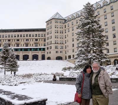
Harumi and Jim in front of the Chateau Lake Louise
September 10, 2014

 
Our next stop was Lake Louise in Banff National Park where we met David’s brother Jim and his wife Harumi.  Our first day together was quite nice but then surprise, snow!  We had three days of snow falling off and on with as much as 6 inches on the ground at a time.  We made the best of it and did some short walks around Lake Louise and then car touring along the Icefield Parkway to the Athabasca Glacier and also a visit to nearby Yoho National Park.  We indulged in some very good local cuisine and then all too soon, it was time for Jim and Harumi to go home.


The unexpected snow was just beautiful!

Lake Louise


The weather was supposed to be warming soon but we were weary of cold and ready to do some serious hiking again.  We thought we might have better luck if we headed south, so off we went to Waterton National Park on the Canadian side of the border from Glacier National Park in Montana.  All I can say is when you don’t have Internet and are out of range of most communications, surprises are inevitable.  We should have checked the weather…

 
David's Stats:
Days Hiked   4
Rain and/or Snow Days  4        
Total Miles Hiked   31.59   
Ave. Miles per Day      7.9
Total Elevation Gain     4,280
Ave. Elevation Gain per day   1,070


Thank goodness for a campground with electricity!


Wednesday, September 10, 2014

Trying to stay warm in Lake Louise


Lake Louise after snow


We are enjoying the Canadian Rockies with newly-weds, Jim and Harumi.  I can’t believe it but we have had three days of snow!  The ground is still warm so it doesn’t stay long, but we have probably had over 6 inches the last two days. 

 
Harumi and Jim at Emerald Lake


Needless to say, we have not been doing a lot of hiking.  But we are all enjoying sightseeing and walks in the snow followed by hot beverages.  Greetings to all and I’ll catch you up on our adventures in about a week.