 |
| Continental Divide Trail at top of Cottonwood Pass |
 |
View looking northwest from top of Cottonwood Pass
Picture taken at same place David and Maya are standing
in top photo but looking west.
|
West of downtown Buena Vista, Cottonwood Canyon climbs to
the Continental Divide Trail (CDT) at the top of Cottonwood Pass. This beautiful canyon borders the Collegiate
Peak Wilderness, home to eight “14ers” or peaks over 14,000 feet in
elevation. In addition, the Colorado
Trail, CDT, Mt. Yale Trail (a 14er) and several other trails can be accessed in
Cottonwood Canyon. Just our kind of
place and only a few miles away, so off we went.
 |
| Entering the Collegiate Peaks Wilderness from the CDT at Cottonwood Pass |
 |
| Indian Paintbrush and Blacktip Senecio growing beside the Denny Creek Trail |
Since it was our first day of climbing over 11,000 feet and we didn’t want to leave Maya all day, we opted for the lake rather than the 14,196 ft. Mt. Yale. We knew we could make the lake and back in three or so hours, but were pretty sure it would take us all day to climb Mt. Yale (if we even could). Also, the summer rains seemed to have arrived as afternoon thunderstorms were predicted for the whole week. Getting caught on the top of a 14er during a thunderstorm would not have been our idea of fun.
 |
| Yellow Paintbrush on alpine slope |
We had a nice hike and arrived back at camp about an hour
before the thunderstorm hit. I talked to
a guy and 2 girls camped near us that had just barely gotten down from Mt. Yale
before the rain started. It took them 8
hours round trip – 5 hours up and 3 down.
It was the girls’ first 14er and they were happy to have made it. But they weren’t planning another one any
time soon.
 |
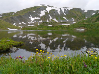
One of the beautiful alpine lakes on the trail to Ptarmigan Lake
This one wasn't named on our map.
|
It rained off and on all afternoon, but we managed to get in a little birding with Maya before dinner. Our campsite was next to a creek and wetland area, so this made for great birding. I have never seen so many Wilson’s warblers in one place. (For those who don’t know them, they are bright yellow birds with a black head that looks like they have a flat top.) The trees were full of them, like American Goldfinches are in Texas in the summer.
 |
 |
Descending into the basin from the South Texas Creek Trail
Collegiate Peaks in the distance
|
The next morning on our way back from the bathroom, David,
Maya and I saw a young male moose wandering through the campground about 10
yards away. I’ve never seen one so
close! And of course, I didn’t have my
camera with me. Lesson: Don’t even go to the bathroom without a
camera. You just never know…
 |
| Alpine daisies only grow about 3 or 4 inches high above timberline |
 |
| I'd never seen paintbrush this color before -- so subtle |
So, this became our pattern for the week. Early morning walks with Maya (carrying our
camera now), then David and I off to a trail for a 3 to 4-hour hike, afternoon
rains and reading, evening birding and of course, meals in between. I’ll let the pictures tell the stories of the
rest of our hikes, but in brief, we hiked twice on the CDT from the summit of
Cottonwood Pass at 12,126 feet. First, we went north on the South Texas Creek
section of the CDT, entering the Collegiate Peak Wilderness again. This trail descended into a lovely alpine
basin with thousands of tiny wildflowers.
 |
Another one of those gorgeous lakes!
Most of our hikes were cloudy and we were lucky to get down before the rains started.
|
Two days later we hiked the southbound section of the CDT from Cottonwood Pass. This section was all above timberline and once we reached about 12,400 feet we lost the trail in the snow. David got off the snow field and scrambled up a rocky slope. He found the trail but it was going to be tough to follow in all the snow so we decided to come back down.
 |
It almost looks like David is skiing, but that is the CDT
It was steep and still very snowy, so we turned back.
|
In between these two CDT hikes, we made a beautiful hike to
Ptarmigan Lake. The trail was on a north
facing slope, so it was a much wetter forest and reminded us of hikes in Oregon
and Washington in the temperate rain forests. The last mile or so was mostly
above timberline as was Ptarmigan Lake. We
saw one pika (small hare like animals with rounded ears and no tail that are
found near timberline on rocky slopes) and heard others on the talus
slopes of the higher mountains.
 |
| Ptarmigan Lake |
David’s Stats:
Days
Hiked 4
Rain
Days 5 - afternoon rains
Total Miles Hiked 19.09
Ave. Miles per Day 4.77
Total Elevation Gain 4,369
Ave. Elevation Gain per day 1,092
Total Miles Hiked 19.09
Ave. Miles per Day 4.77
Total Elevation Gain 4,369
Ave. Elevation Gain per day 1,092
 |
| There could still be avalanches up on the high ridges, although small ones |


No comments:
Post a Comment