 |
| Southbound on the Continental Divide Trail (CDT) near Monarch Pass |
 |
The first emblem stands for the Continental Divide Trail
and the second one for the Colorado Trail
|
David and I have hiked several sections of the Continental
Divide Trail (CDT) in New Mexico and Colorado and a couple of sections in
Wyoming and Montana in past years when we traveled in the Rocky Mountains. The CDT is probably the least well known of
the "triple crown" hikes in the United States. Most people have heard of the Appalachian
Trail on the east coast and many know of the Pacific Crest Trail on the west
coast. But it is surprising how few know
that you can roughly follow the Continental Divide on a 3,100-mile trail from the
border of Mexico to the border of Canada. Chances are very good that David and I will
never make the journey from Mexico to Canada. But we plan on adding new parts of the trail
(for us) every time we travel west.
 |
| Views to the north from the CDT southbound |
 |
| A yellowbellied marmot poses for us |
 |
| Not to be outdone, a golden-mantled squirrel poses too |
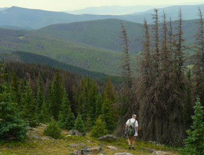
While we were in the Monarch Pass area we hiked the CDT
twice, one time going south from the pass towards New Mexico and the other hike
was headed north towards the Collegiate Peaks in Colorado. Then we hiked another section in far southern
Colorado near Cumbres Pass.
Our southern hike from Monarch Pass was on a very popular section of the
trail that is also part of the Colorado Trail (CT). The CT is a trail that runs 486 miles from
Durango to Denver. David and I tend to
pick out trails that are in wilderness areas or are restricted to hikers and
horseback riders but on this well-loved part of the shared CDT and CT bicycles are
allowed.
 |
| David waits for a cyclist to pass. |
There were many cyclist and most were extremely considerate and no problem
for us, it just made for a very busy trail.
One group of cyclists had a drone hovering above filming their
ride. Modern technology! I guess we shouldn’t have been
surprised at the crowd as it is an easy part of the trail to reach. And Monarch Pass is a popular stopping place
for tourists. There is even a gondola
ride that takes tourists up for a view of the surrounding mountains. Fortunately, the crowded trail didn’t last
long. Most cyclists started early and flew
past us, so after 10:30 the trail settled down to just a few of us slow hikers.
 |
| Great views from just above timberline |
Monarch Pass is above 11,000 feet so it didn’t take us long
to reach timberline. In several places
we had 360-degree views of all the surrounding mountains. One barren slope had a small stand of
bristlecone pines, a favorite tree of ours.
Bristlecones are some of the longest-lived trees in the world, some
being over 4,000 years old like the intermountain bristlecones we saw in
California a few years ago. The Colorado
bristlecone species on this trail are the shorter-lived of the bristlecones
only reaching about 2,400 years old.
 |
| A dead and live Colorado bristlecone pine |
 |
| Alpine sunflower, one of my favorite alpine flowers |
The next day we crossed Highway 50 and hiked northbound on
the CDT. Our experience was so different
on this part of the trail. The first
mile was on a ski road that traversed the Monarch Mountain Ski Area and we didn’t
see a soul on this part of the trail.
After we hiked past the ski area, the trail turned off the road and
slowly wound through a spruce and fir forest which slowly gave way to a large
bristlecone pine forest and then the trail went above timberline for many miles. This section was restricted to
foot and horse travel only and we only saw a few hikers.
 |
Alpine flowers struggle to grow and bloom above timberline.
We are careful not to get off the trail and damage these fragile flowers.
|
The hikers we met were Colorado Trail ‘thru-hikers,’ which
meant they had started the trail earlier in the summer south of Denver at
Waterton Canyon and were hiking all the way to Durango. We talked to one hiker named Austin who was
from Tennessee. Austin was so happy
because it looked like he was going to make it all the way to Durango. When he started the trail 6 weeks ago, the
fires near Durango were not contained and that part of the CT as well as much
of the San Juan Forest had been closed.
 |
On the northbound CDT we saw Waterdog Lakes from above.
We had had lunch on the shore below just two days ago.
|
Since Austin had bought his ticket and planned his hike
months ago, there was nothing to do but start hiking and hope for the
best. Austin got off to a very rough
start as it was 106 degrees the day he started on the CT and he came down with
heat exhaustion on his second day. He
took a few days off to rest and started back on the trail with much more water
in his pack. When we talked with him he
looked sunburned and pretty skinny, but he was happy to be only a few
weeks away from his goal of finishing the CT.
David and I both admired his determination and bravery, hiking this
trail alone in such a hot, dry and fire-prone year. After finishing this adventure, Austin’s
plans were to go back to Tennessee and go to nursing school. We wished him our very best.
 |
| Continental Divide Trail from Cumbres Pass |
 |
| Cumbres-Toltec Scenic Train climbing the pass as seen from the CDT |
Our last hike on the Continental Divide Trail was near the
border of New Mexico near Cumbres Pass.
This part of the trail was a lot of fun because the Cumbres-Toltec
Railroad, a narrow-gauge train that is now a tourist train, climbs through the
pass in this area. We were lucky to get
glimpses of the train winding through the pass in several places. As we returned from our hike and were heading
back to camp, the train crossed the road right in front of us. Steam was bellowing and the whistle was
blowing as the train chugged up the grade. We’ve always wanted to ride this train and now
we really want to because we’ve seen how beautiful the pass is. The slopes are covered with aspens, so this
would be a great train ride to take some fall.
 |
| This little train works hard through the pass spewing smoke and steam |
We’ve crossed into New Mexico now and are making our way
back to Texas. It is going to be a hard
adjustment as we are now totally spoiled to cool weather. It’s been in the 50s most mornings and I am
used to sleeping with blankets. I don’t
think that is going to be the case when we get back to Texas. Anyhow, we have a few more days in the
mountains before we head home so I just won’t think about the heat yet.
 |
| Scarlett gilia |
 |
| Blue bells |
David’s Stats:
Days
Hiked 4
Total Miles Hiked 25.5
Ave. Miles per Day 6.38
Total Elevation Gain 4,000
Ave. Elevation Gain per day 1,000
Ave. Miles per Day 6.38
Total Elevation Gain 4,000
Ave. Elevation Gain per day 1,000
No comments:
Post a Comment