 |
Miners Castle on Lake Superior
Pictured Rock National Lakeshore |
Leaving Tahquamenon Falls and clouds of mosquitoes in our
rear view mirrors, we traveled north and west for the shores of Lake
Superior. The city campground in the
town of Munising had been recommended to us by many of the campers we met at
the RV park in East Tawas that we visited a few weeks ago. Since Munising is located at the western
entrance to Pictured Rocks National Lakeshore, we decided to give the
campground there a try while we explored the Pictured Rocks.
 |
Sunset on Lake Superior from our campground
So nice to be out at sunset without the mosquitoes! |
Things were a bit crowded at the city campground but
otherwise the place was nice. We didn’t
get a campsite right on the beach but we had a good view of Lake Superior and
it was less than a hundred yard walk to the beach. And the best thing was – hardly any
mosquitoes! Those famous lake breezes
kept them away. Thank you, big lake
Kitchi Gummi!
 |
Believe it or not, that is tree pollen in the lake!
Many of the trees in the U.P. are just now leafed out and finishing with pollination |
Lake Superior is our last Great Lake to visit and after our
first sightings a few days ago at Tahquamenon Falls State Park we were glad
for the chance to camp near her shores and spend more time enjoying and getting
to know this legendary lake. Called
Kitchi Gummi by the Chippewa (and “Gitche Gumee” by Henry Wadsworth Longfellow
in “The Song of Hiawatha” and Gordon Lightfoot in “The Wreck of the Edmund
Fitzgerald”), Superior is the largest Great Lake by surface area and the second
largest lake on Earth by volume, containing about 10 percent of the Earth’s
fresh water. Another way to picture that
is to think about a four-foot deep swimming pool the size of the continental
U.S. – that is how much water is contained in all of Lake Superior! The distance around the whole lakeshore is
2,726 miles, close to the distance between Montana and Florida. Being from a water-deprived state with only
one natural lake, we were more than impressed with the size and grandeur of Lake
Superior and all the Great Lakes for that matter.
 |
Grand Sable Banks and Dunes from Log Slide Overlook
People were running down this 500-foot dune and spending hours climbing back up |
Pictured Rocks National Lakeshore preserves a spectacular
stretch of colorful sandstone cliffs and sand and cobblestone beaches along
Lake Superior’s southern shoreline. The
park also contains numerous waterfalls, streams, northern forests and wildlife
plus the historic Au Sable Light Station and other cultural resources. There is as much to see inland as near the
lakeshore, but the ‘Pictured Rocks’ cliffs that give the park its name are best
viewed from the water.
 |
| Miners Falls |
We spent one day driving from the Munising entrance of
the park to the small town of Grand Marais, the entire length of the park and
over 60 miles. Stopping at numerous pullouts and overlooks
along the way, the drive took us nearly all day including our stop for lunch in
Grand Marais. Miners Castle, Miners
Falls, Miners Beach, Sable Falls, the Log Slide Overlook and Twelvemile Beach
were among our stops. We would have
liked to do more hiking but unlike Sleeping Bear Dunes National Seashore which we
recently visited in lower Michigan, Pictured Rocks does not allow pets on most
trails. Still, we got a good feel for
the park and were able to do a couple of shorter trails to the waterfalls
with Maya.
 |
An Upper Peninsula tradition, Pasties are meat and vegetable "pies"
We bought these from Muldoon's in Munising, supposedly voted
the best in the U.P. and they were good!
|
The highlight of our time was the late afternoon cruise
we took along the Pictured Rocks Cliffs.
Yes, it was a three-hour cruise but all went well and we returned safely
after a wonderful afternoon on the water.
The sandstone cliffs almost glowed in the dramatic lighting and we saw
the moon rise over some of the cliffs.
The park definitely deserves its name and I very happily ‘pictured
rocks.’ (See below...)
 |
| Bridal Veil Falls |
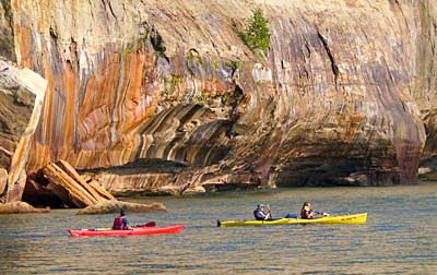 |
Kayakers checking out the colorful cliffs
We are definitely going to do it this way next time! |
 |
Moonrise over Pictured Rocks Cliffs
The color streaks are caused by minerals such as iron and manganese |
 |
| The Portal has partially collapsed and can't be sailed through anymore |
 |
| Spray Falls plunges into Lake Superior |
 |
| Lover's Leap |
David’s Stats:
Days
Hiked: 1
Total Miles Hiked: 4.34
Total Elevation Gain: 661
 |
| Heading for shore. It was a great day! |


No comments:
Post a Comment